fascinating culture
SANRIKU FUKKO
NATIONAL PARK
Hachinohe City, Hashikami Town, Hirono Town, Kuji City, Noda Village, Fudai Village,
Tanohata Village,
Iwaizumi Town, Miyako City, Yamada Town, Otsuchi Town, Kamaishi City, Ofunato City,
Sumita Town, Rikuzentakata City,
Kesennuma City, Minamisanriku Town,
Onagawa Town, Ishinomaki City
What is Sanriku Fukko National Park?
Features|A national park where you can sense both the blessings and threats of nature, and the life and culture nurtured by the coexistence between people and nature.
Designation|May 2, 1955 (designated as Rikuchu Kaigan National Park)
May 24, 2013 (The area was expanded and designated as Sanriku Fukko National Park.)
Area|28,539ha
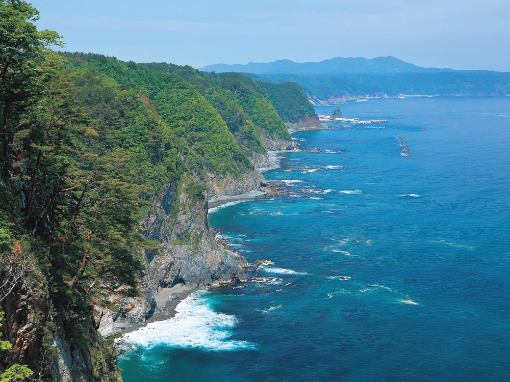
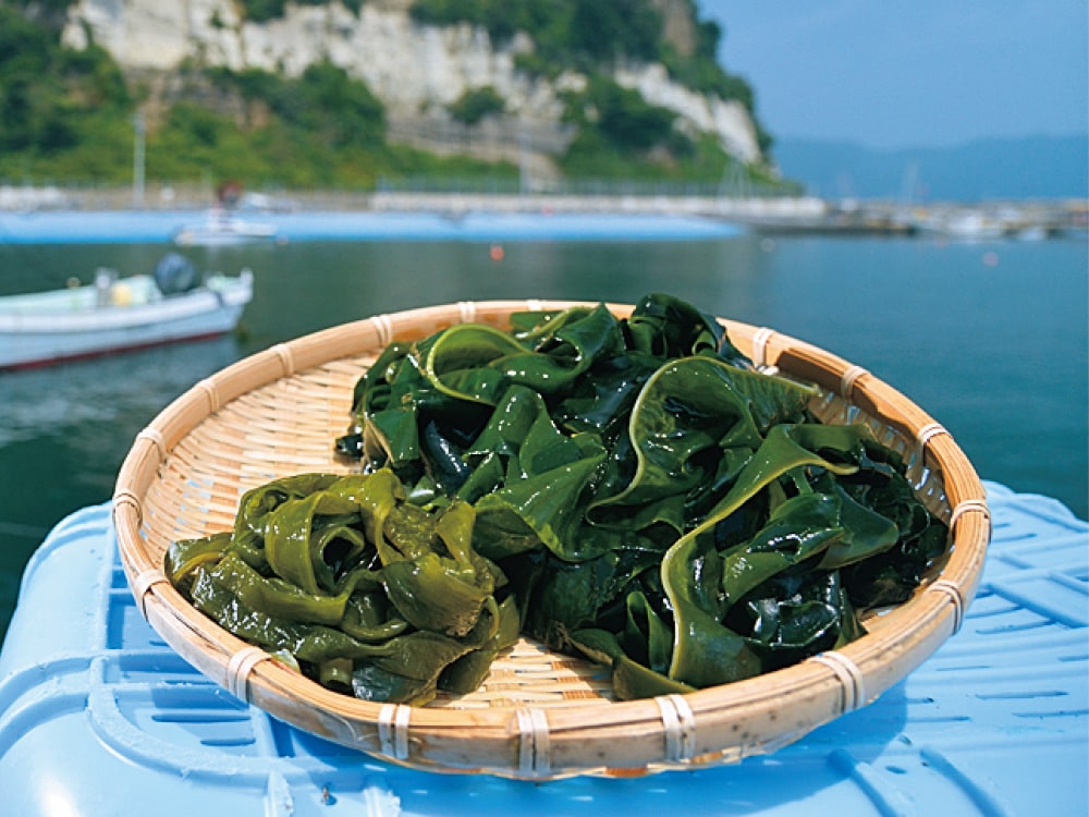
Sanriku Fukko National Park was established on May 24, 2013 to contribute to the reconstruction of the Sanriku area damaged by the Great East Japan Earthquake. The northern part of the park features dynamic cliffs known as the "Alps of the Sea," while the southern part features a series of intricate ria coastlines. In this unique environment, you can observe a diverse range of coastal plants and wildlife up close. The eelgrass and seaweed beds in the coastal waters serve as habitats for various marine organisms. Another attraction is the fresh seafood landed at the fishing ports of Sanriku, which is said to be one of the three best fishing grounds in the world.
Walk along the Michinoku
Coastal Trail
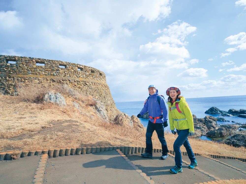
Extending along the Pacific coast, this long trail connects Hachinohe City in Aomori Prefecture to Soma City in Fukushima Prefecture. Enjoy the scenery of the Sanriku Fukko National Park and the ria coastlines, as well as some dynamic mountain hikes and local culinary delights unique to each region while fostering connections with the locals, which contributes to the recovery of the region. The Michinoku Coastal Trail serves as a journey where you can witness landscapes that can only be seen by walking on your own feet, experience the healing power of nature that stimulates all your senses, and discover the culture and warmth of the locals.
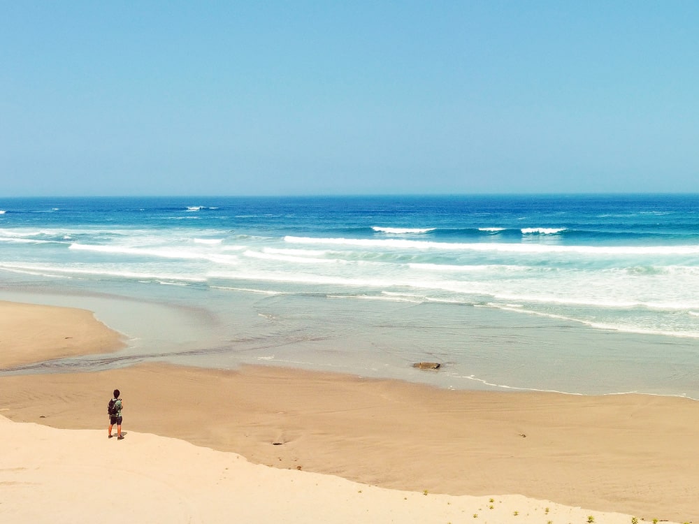
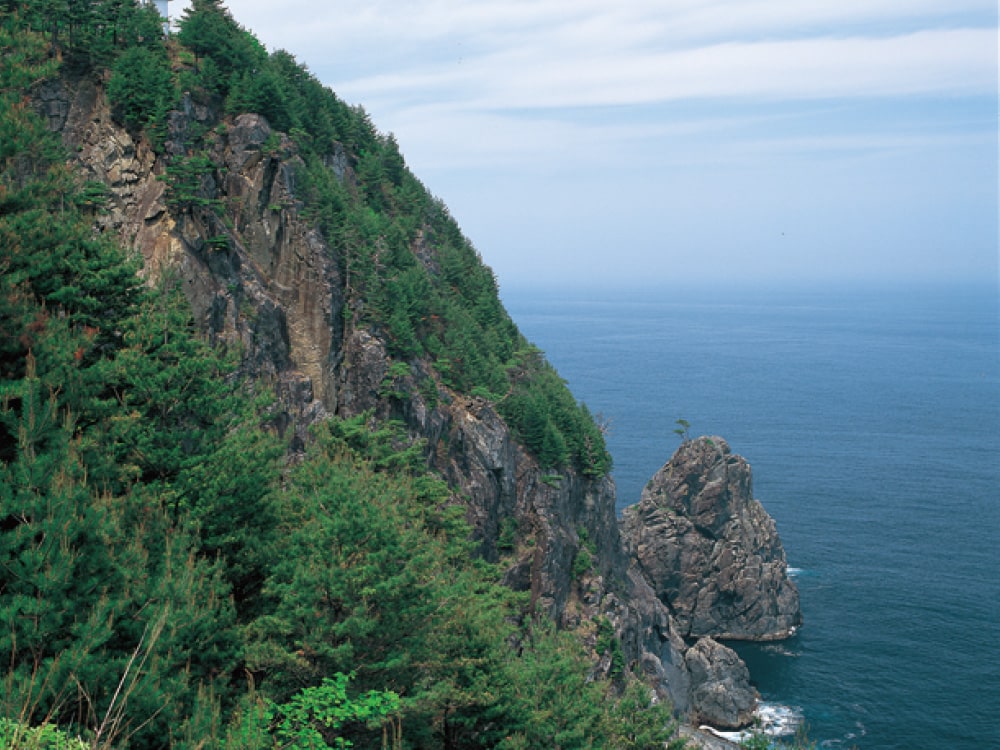
An awe-inspiring road with towering cliffs
This is a path that you can walk along while gazing at the magnificent sea cliffs formed by erosion from the waves. As you travel from north to south, the cliffs become taller. The section between Hachinohe City and Noda Village is relatively gentle, while the route from Fudai Village to Yamada Town requires stamina and skill.
A road along the ria coast and an old highway
This course allows you to enjoy a lifestyle in harmony with nature by circling the Sanriku Hamakaido, which flourished as a trade route, and the peninsula boasting Japan's largest-scale ria coastline.
A road for enjoying history and culture while overlooking Sendai Bay
Walk along this path to enjoy the scenery of Sendai Bay and the history and culture of the area. You can climb the Abukuma Plateau and walk along the Teizanbori Canal, which were used for maritime transportation, allowing for a diverse range of enjoyable experiences.
Preparing for the trail
- 1.Gather information from the official Michinoku Coastal Trail website.
- 2.Request the trail maps for the walking sections.
- 3.Plan thoroughly, make preparations, and then set off on your journey.
Thorough preparation is crucial for the trail. Check the information on the official website to ensure a comfortable and enjoyable experience on the day of your hike.
Michinoku Coastal Trail Official Website https://m-tc.org/en/

To purchase a map, please contact the Michinoku Coastal Trail Natori Trail Center. Tel: 022-398-6181
Trail Notes:Take into account your fitness level and the weather, and create a realistic plan before starting. To safely enjoy the trail, plan for meals and rest locations, check for any hazardous areas along the route, and confirm the locations of emergency shelters.
Ministry of the Environment/Tohoku Regional Environment Office6F Sendai Godochosha Bldg.No.2, 3-2-23 Honcho, Aoba-ku, Sendai, Miyagi 980-0014
Tel: 022-722-2874
Scenic views await
as you walk
# Michinoku Coastal Trail
Discover the terrain
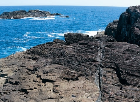
Cape Osaki
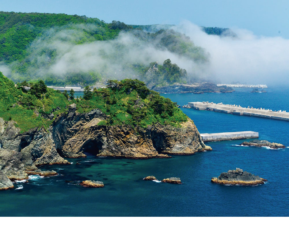
Located at the innermost part of the Karakuwa Peninsula, this cape is known for its series of magnificent rocky reefs created by sea erosion and the spectacular view of the Pacific Ocean's mighty waves crashing against the shore.
Discover nature
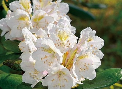
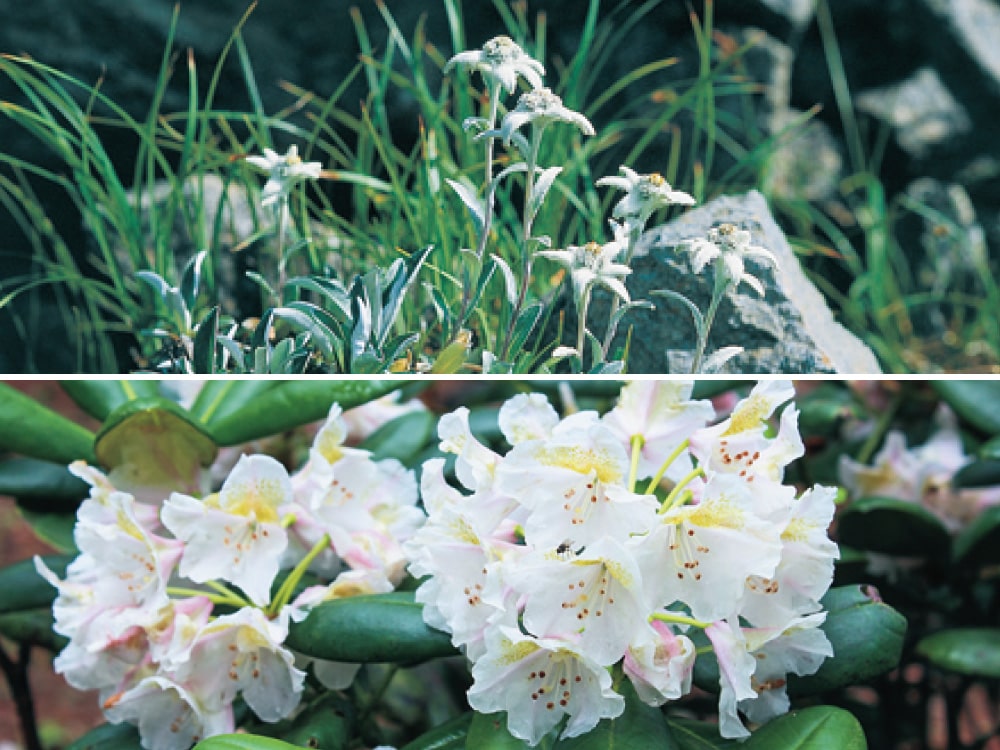
Shirobana Rhododendron
Along the cool and refreshing coastline of northern Sanriku, you can witness the sight of plants that typically grow at higher altitudes, even in the summer. The white-flowered rhododendrons that thrive on the cliffs of Kitayamazaki are in full bloom from early to mid–June.
Discover wildlife
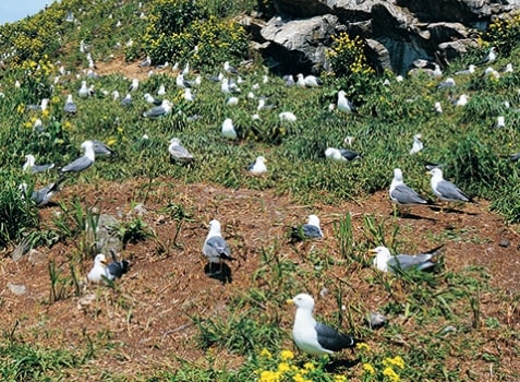
Black-tailed Gulls
on Kabushima Island
Kabushima Island is designated as a national natural monument and breeding ground for Black-tailed Gulls. Every year, from spring to summer, an estimated about 30,000 Black-tailed Gulls migrate to the island to breed and raise their young.
Discover culture
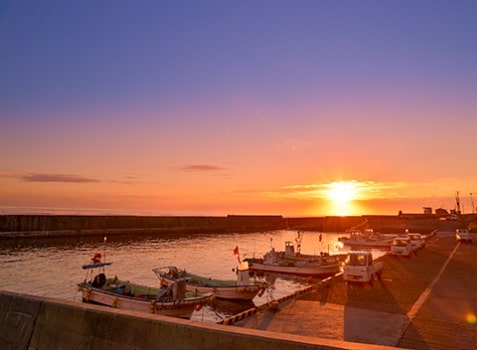
Fishing port in the morning
Before dawn, during the early hours of the morning that can still be considered as late at night, fishermen set sail and return to the harbor as the sunrise begins. This marks the start of the workday on the coast.
The 5 appealing points of
Sanriku Geopark
Sanriku Geopark allows you to experience and enjoy the rich history of the Earth, the history of tsunamis, the abundance of nature, and the activities of the local people, spanning approximately 500 million years.
A geopark is a combination of the words "geo" (meaning earth or land) and "park," which signifies a "park of the Earth." It is a place where you can learn about and enjoy the connection between nature, the local communities, their way of life, and the history and culture associated with the area.

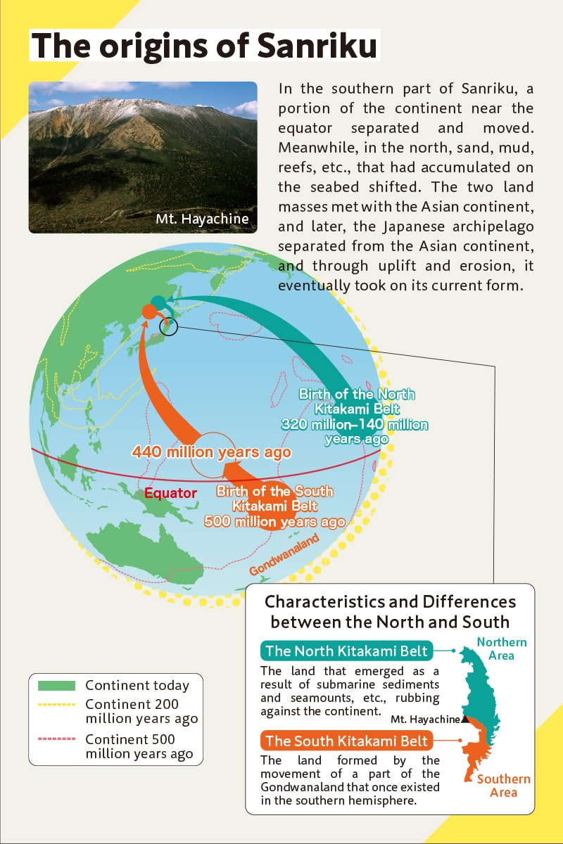
Diverse landscapes from 500 million years ago
The Sanriku region bears the imprints of approximately 500 million years of history, featuring a variety of landscapes created through the uplift and erosion of the Earth.
The origins of Sanriku The origins of Sanriku
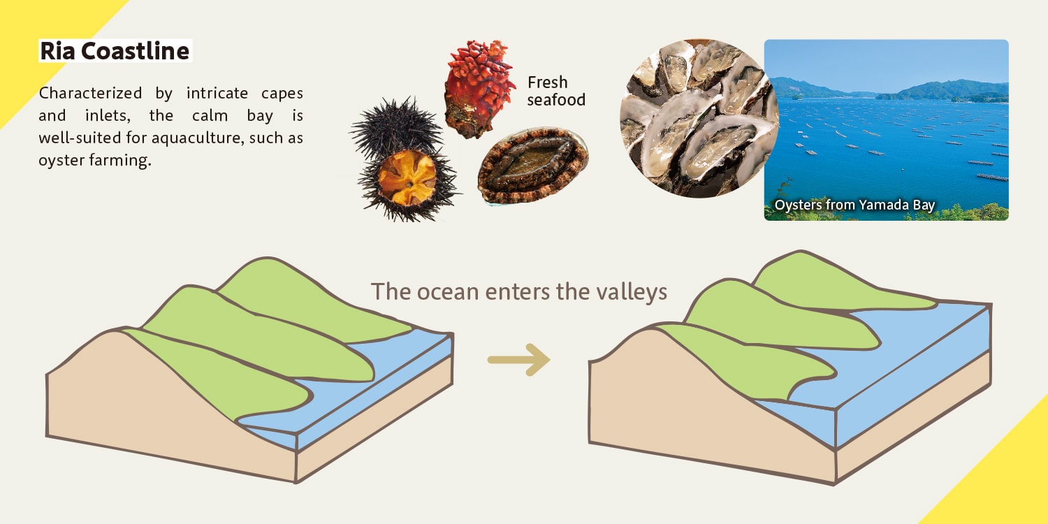
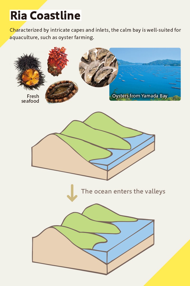
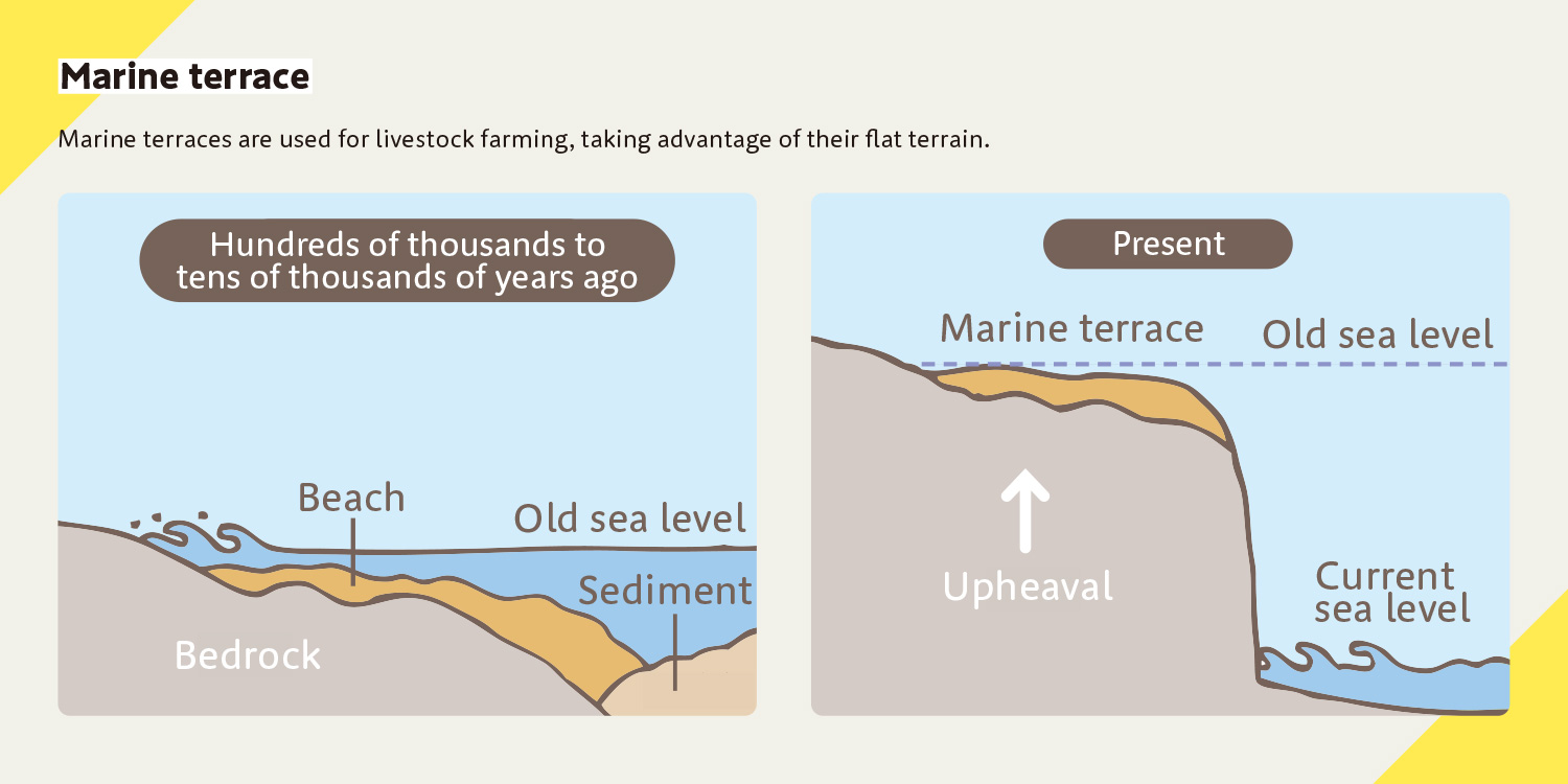
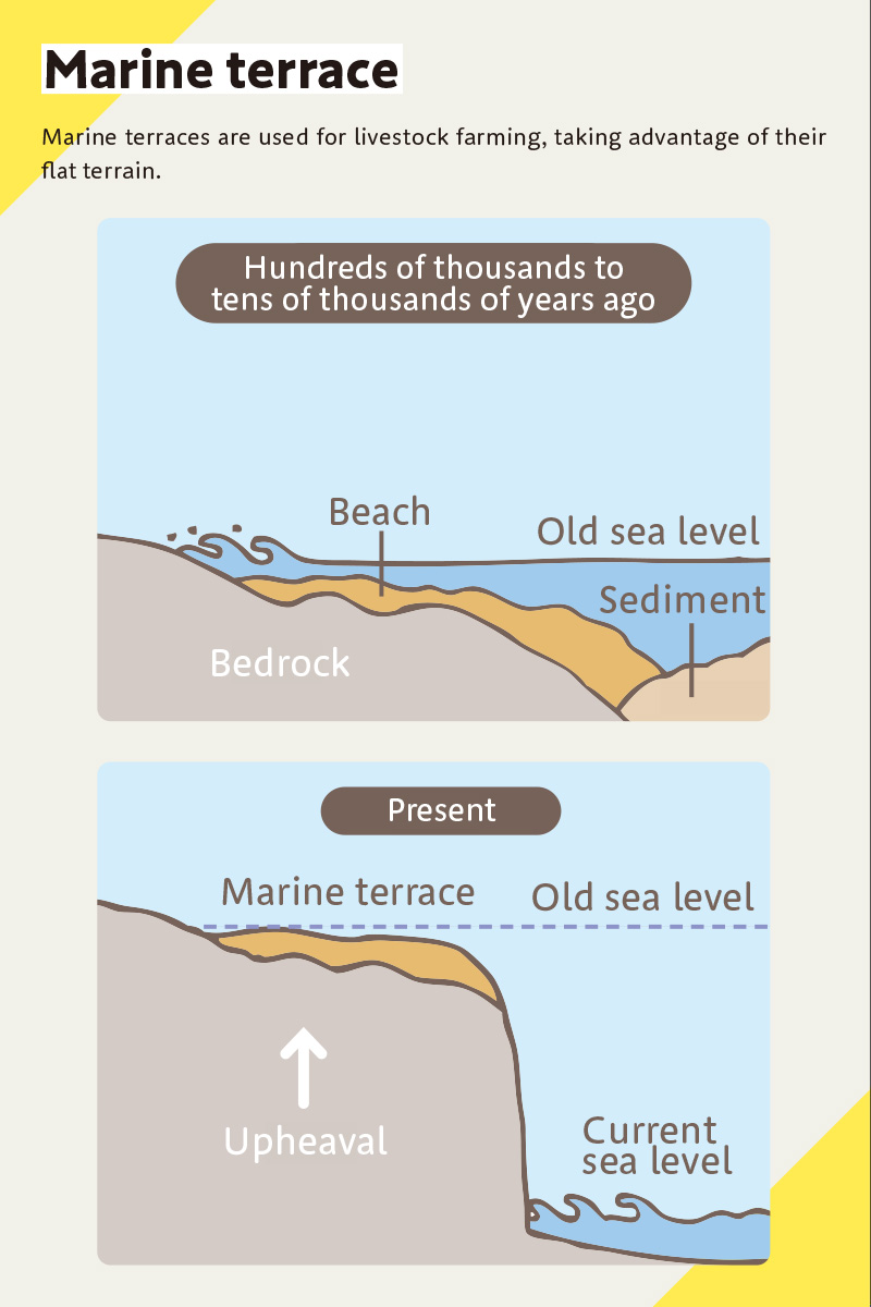
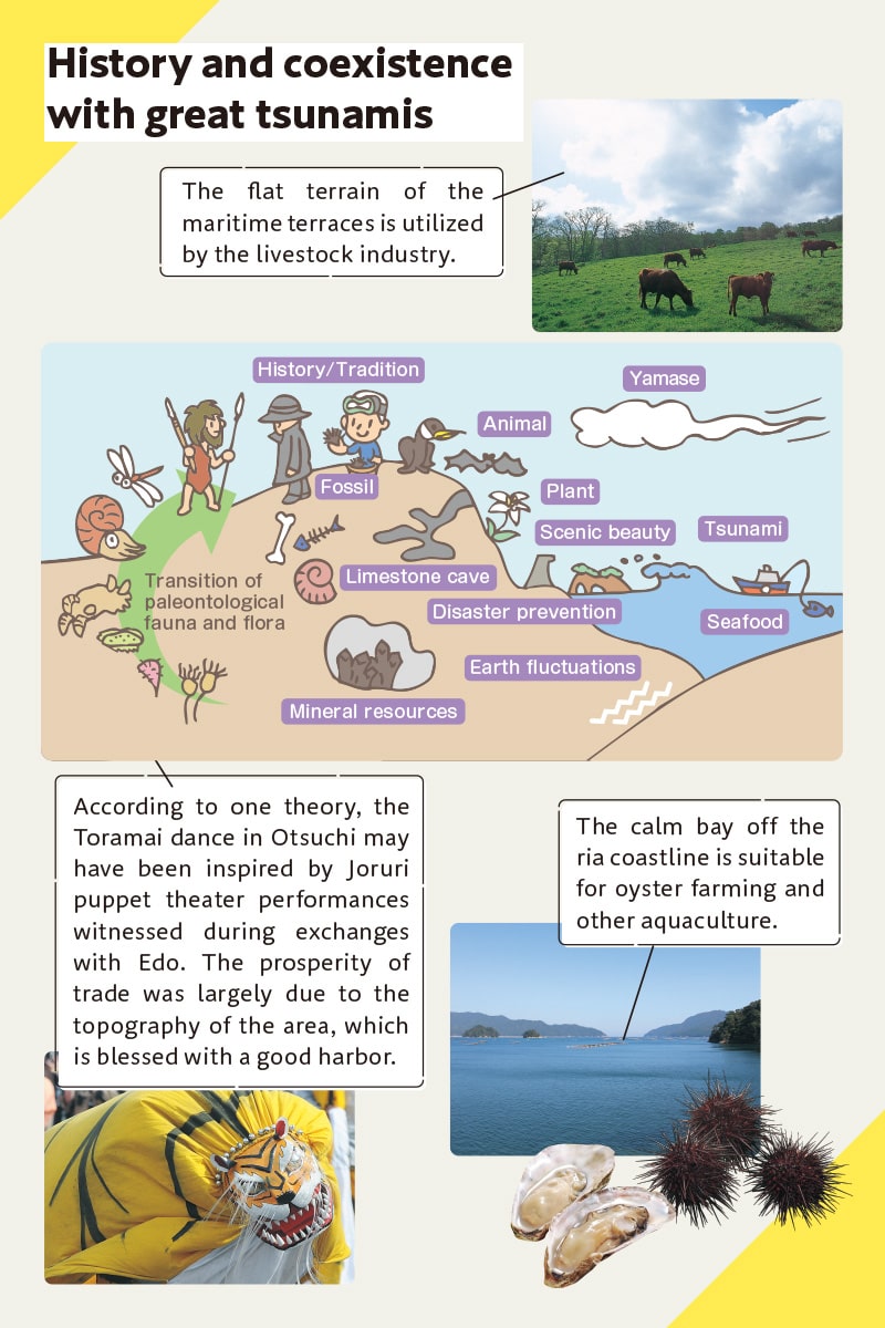
Ria blessings and terrace activities
The ria coastline is characterized by a coastline of repeating inlets and capes, formed by the sea entering deep valleys carved by rivers. The marine terraces feature a series of terrains and cliffs that emerged onto the land due to the uplift of the Earth's surface and changes in sea level, resulting in a straight coastline that was once a flat seabed near the shoreline.
A one-of-a-kind ecosystem
Within the diverse ecosystem, you can witness unique species like Hayachine-Usuyukiso (Leontopodium hayachinense ) plants thriving due to distinctive geology and rocks, as well as alpine plant communities nurtured by harsh weather conditions such as yamase, the cold Pacific wind.
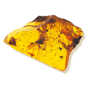
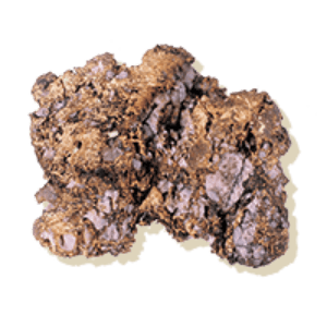
Abundant underground resources
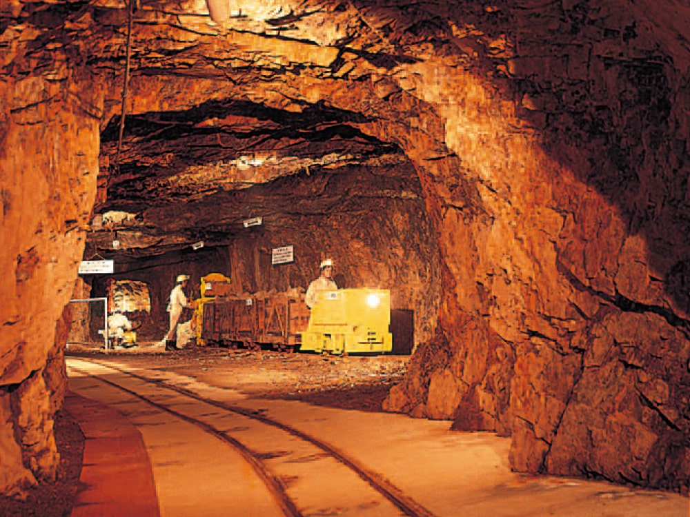
The rich resources of Sanriku have supported the region, including the renowned production of Kuji amber, the Kesen Gold Mine that supported the gold culture of Hiraizumi, and the Kamaishi Mine, which laid the foundation for modern steelmaking.
History and coexistence with great tsunamis
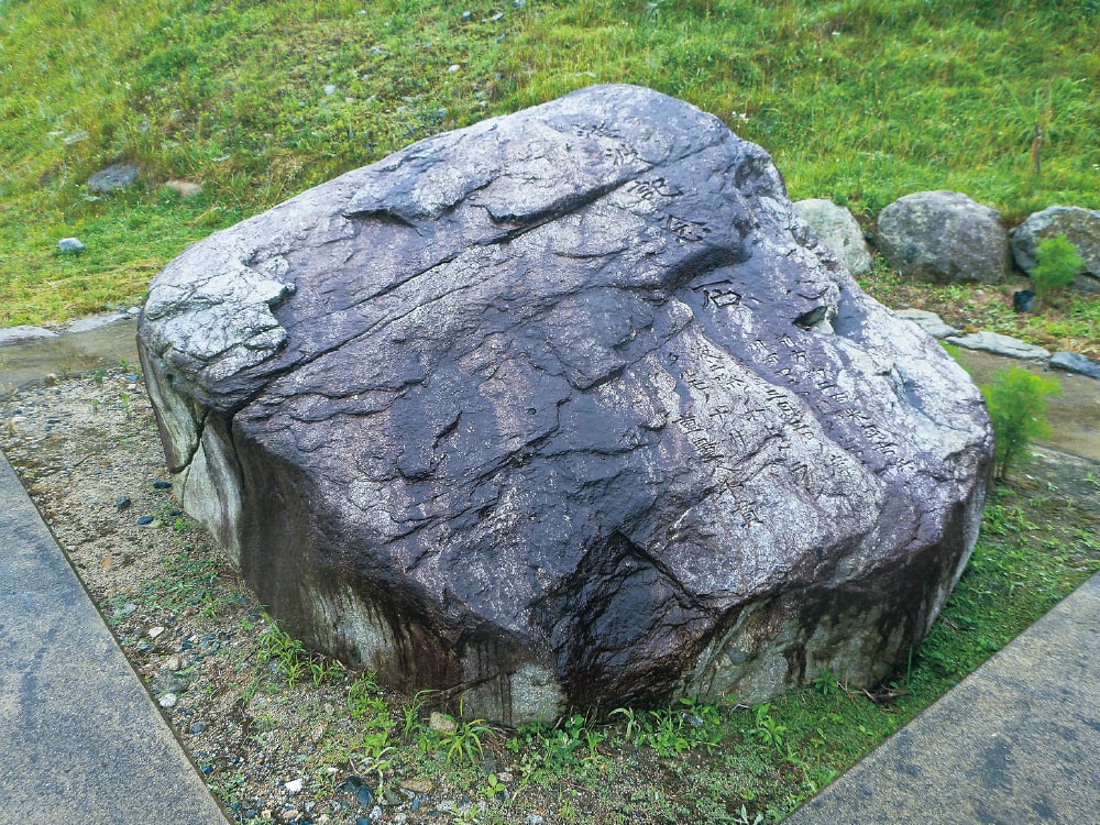
The offshore region of Sanriku is an area that is frequently struck by earthquakes and tsunamis due to the subduction of the Pacific Plate, and the memory of past major tsunamis is preserved in the ancient geological layers. Sanriku serves as a field where wisdom and lessons of coexistence with tsunamis can be passed on.
Click here for details Click here for details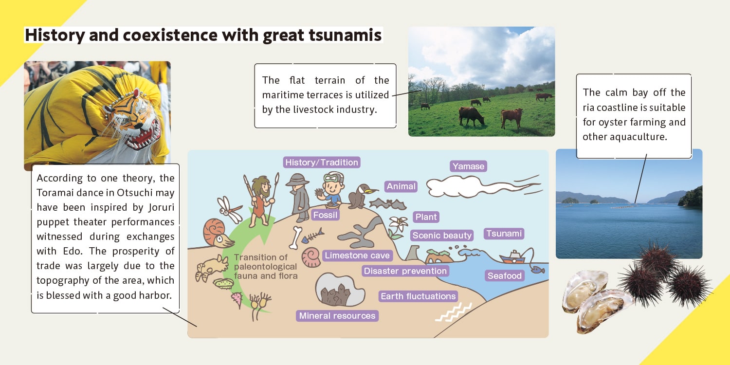
The five appealing points, the local food, the culture (local performing arts, etc.), and the people's way of life are deeply connected to the history of the land.
gourmet & activities!
Things to do
in Sanriku Fukko National Park!
The magnificent views of the sea and mountains surrounded by abundant nature are not the only things worth experiencing here!
There are plenty of unique activities and gourmet delights that can only be found in Sanriku!

Miyako City sightseeing boat, "Miyako Umineko Maru"
The Miyako City sightseeing boat "Miyako Umineko Maru" commenced its service on July 17, 2022. Connecting Desaki Port and Jodogahama Beach, this new sightseeing boat guides passengers through the Jodogahama area and various sites of the Sanriku Geopark.
Inquiries: Miyako Pleasure Boat Div. , Northern Iwate Transportation Inc./Tel: 0193-65-8856
https://www.jodo-yuransen.jp/en/
Kitayamazaki Sappa Boat Adventure
Ride on a small coastal "Sappa boat" operated by local fishermen, and enjoy a dynamic and exhilarating cruising experience as you tour the cliffs and strangely shaped rocks of Kitayamazaki.
Inquiries: NPO Taikenmura / Tanohata Network/Tel: 0194-37-1211
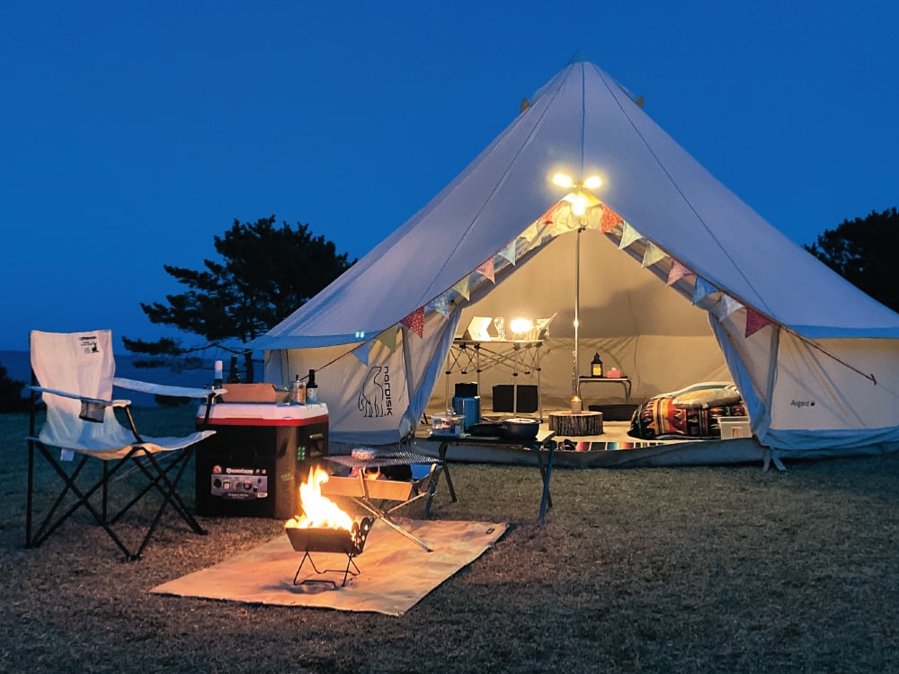
Retreat Camp on the Tanesashi Coast
A retreat camp at the campsite next to the Tanesashi Natural Lawn. Enjoy fresh local ingredients under the starry sky and on the soft lawn.
Transportation: Approx. 3 min walk from JR Hachinohe Line Tanesashi-kaigan Station./Inquiries: AC Promote/Tel: 0178-38-8420
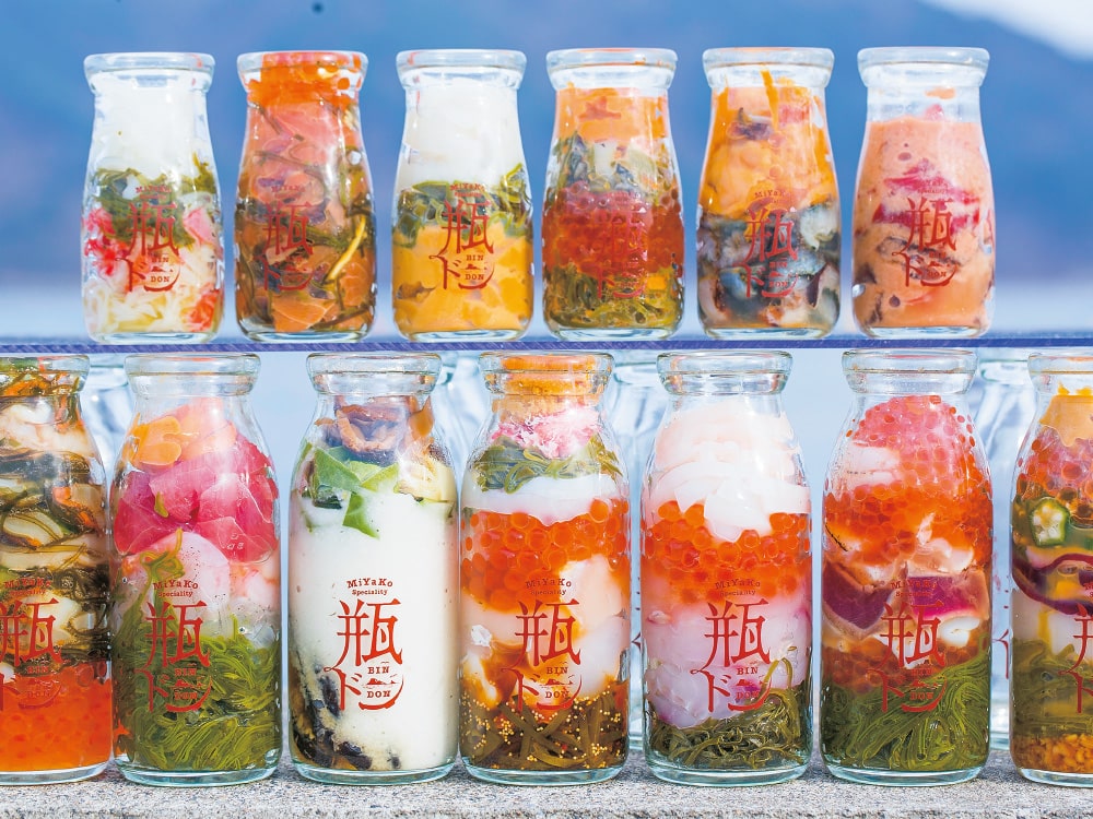
Try a Bin Don
This is a local gourmet dish from Miyako where seasonal ingredients are packed tightly into a milk bottle and then poured over rice for a unique and interactive experience.
Inquiries: Miyako Tourism Culture Exchange Association/Tel: 0193-62-3534
Hachinohe Senbei-jiru Soup
One of the representative local dishes of the Hachinohe region. The chewy texture of Otsuyu Senbei, specially made for soups, is what makes it appealing.
Inquiries: Visit Hachinohe/Tel: 0178-70-1110
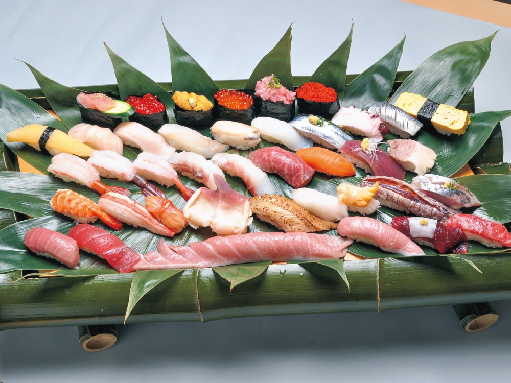
Enjoy the taste of Sanriku with Sushi & Kaisendon
Fresh seasonal seafood from off the coast of Sanriku / Kinkasan Island, one of the world's three major fishing grounds, is available along the Sanriku coastline, allowing you to fully savor its flavors.
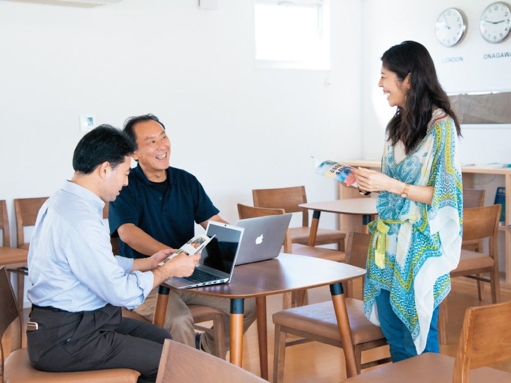
Workcation
With accommodations, a train station, shopping district, and coworking spaces all within walking distance, Onagawa Town is perfect for a workcation.
Inquiries: NPO Asuenokibou/Tel: 0225-98-7175
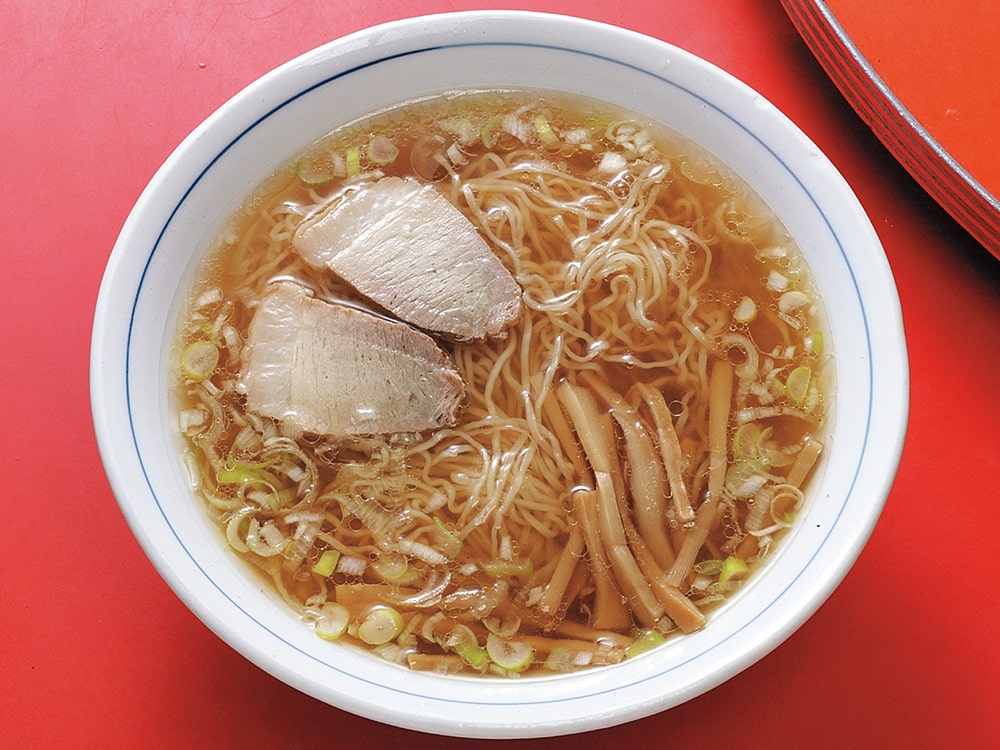
Local Gourmet Kamaishi Ramen
Kamaishi's local ramen is characterized by ultra-thin curly noodles and a clear amber-colored soy sauce-based light broth.
Inquiries: Kamaishi Tourist Information Center
/Tel: 0193-27-8172
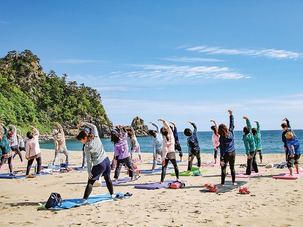
Care for your body with beach yoga
Immerse yourself in the natural surroundings and relax your mind and body at Kiraumi Fudai Beach. Everyone from beginners to families with children are welcome to join.
Inquiries: Fudai Village Tourism Association
/Tel: 0194-35-2115
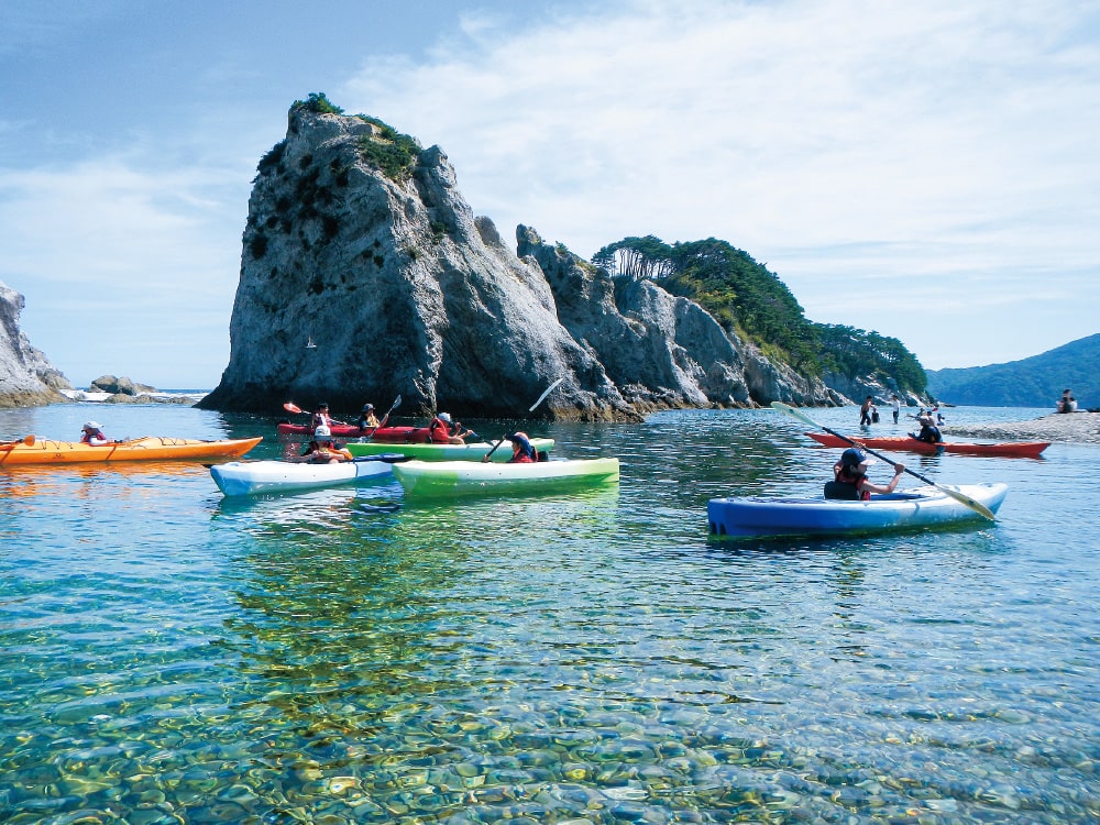
Sea kayaking highly recommended!
A sea kayaking schools and tours are held at Jodogahama, one of the most scenic spots in Sanriku. They offer a variety of programs that can be enjoyed by beginners and experienced kayakers alike.
Inquiries: Sanriku Sea Kayak School Sea-son
/Tel: 090-4550-0250
https://www.sea-son.net/
NorthernArea
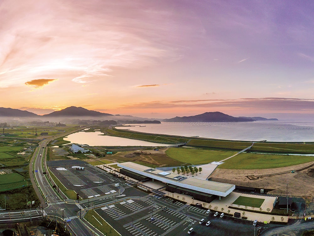
From the Tanesashi Coast to a morning market and gourmet foods, Hachinohe’s diverse coastline and abundant sea offer countless attractions.
Tourist accommodation information & inquiries:
Tourist Information Center, Hachinohe City/Tel: 0178-27-4243/2nd floor of the Hachinohe Station/https://visithachinohe.com/en/
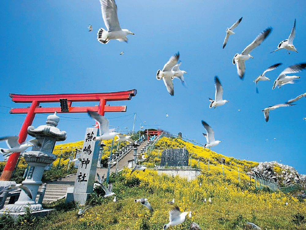
Kabushima Island
National Natural Monument
Located at the northernmost tip of Tanesashi Coast, this National Natural Monument is a breeding ground for black-tailed gulls.
Access: Approx. 15 min walk from Same Station
Tel: 0178-70-1110 (Visit Hachinohe)
Its sea, mountains, and lighthouse create a picturesque scenery. This easternmost town in Aomori Prefecture is known for having the earliest sunrise in the prefecture.
Tourist accommodation information & inquiries:
Industrial Promotion Division, Hashikami Town/Tel: 0178-88-2875/1-87 Aza-Tentotai, Dobutsu, Hashikami, Aomori/https://www.town.hashikami.lg.jp
Mt.
Hashikamidake
From the summit of Mt. Hashikamidake, which stands at an elevation of 739.6 meters, you can enjoy a magnificent panoramic view of the sea and mountains. The full bloom of mountain azaleas in early summer is a must-see.
Access: Approx. 15 min by car from Hashikami Station to the trailhead
Tel: 0178-88-2875 (Hashikami Town Industrial Promotion Division)
One of the leading sea urchin production areas in Japan, Nanbu Moguri, and farms spread across the highlands of Ohno Marine Terrace are found here. The town has both a sea and a highland farm.
Tourist accommodation information & inquiries:
Fisheries Commerce and Industry Division, Hirono Town/Tel: 0194-65-5916/23-27 Taneichi, Hirono, Iwate/https://www.town.hirono.iwate.jp
Taneichi
Seaside Park
A beach with white sandy shores. It is also a popular surfing spot with facilities such as campgrounds and hot water showers.
Access: Approx. 20 min walk from Taneichi Station
Tel: 0194-65-5916 (Fisheries Commerce and Industry Division, Hirono Town)
A city where you can find Hiraniwa Highland, which is Japan's finest white birch forest, as well as ancient gifts of amber, and the Northernmost Ama Divers who uphold traditional fishing methods.
Tourist accommodation information & inquiries:
Kuji City Tourism and Products Association/Tel: 0194-66-9200/2-5-6 Nakamachi, Kuji, Iwate
Kuji Area Tourism Council/Tel: 0194-52-0177/3-38-2 Chuo, Kuji, Iwate (Inside Sanriku Railway Kuji Station)
Kuji
Amber Museum
The only amber museum in Japan. You can enjoy activities such as amber excavation and accessory making.
Access: Approx. 15 min by car from Kuji Station
Tel: 0194-59-3831
"Noda Shio Beko no Michi (Cattle Trail carrying Noda Salt)" is a treasure of Noda Village's history and culture. This life-sustaining salt was carried on the backs of cows.
Tourist accommodation information & inquiries:
Future Development Promotion Division, Noda Village/Tel: 0194-78-2963/20-14 Noda, Noda, Iwate/https://www.vill.noda.iwate.jp
Noda Village Tourism Association/Tel: 0194-78-2012/19-117 Noda, Noda, Iwate/https://www.noda-kanko.com
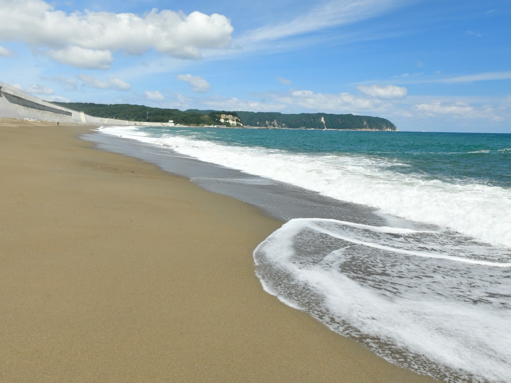
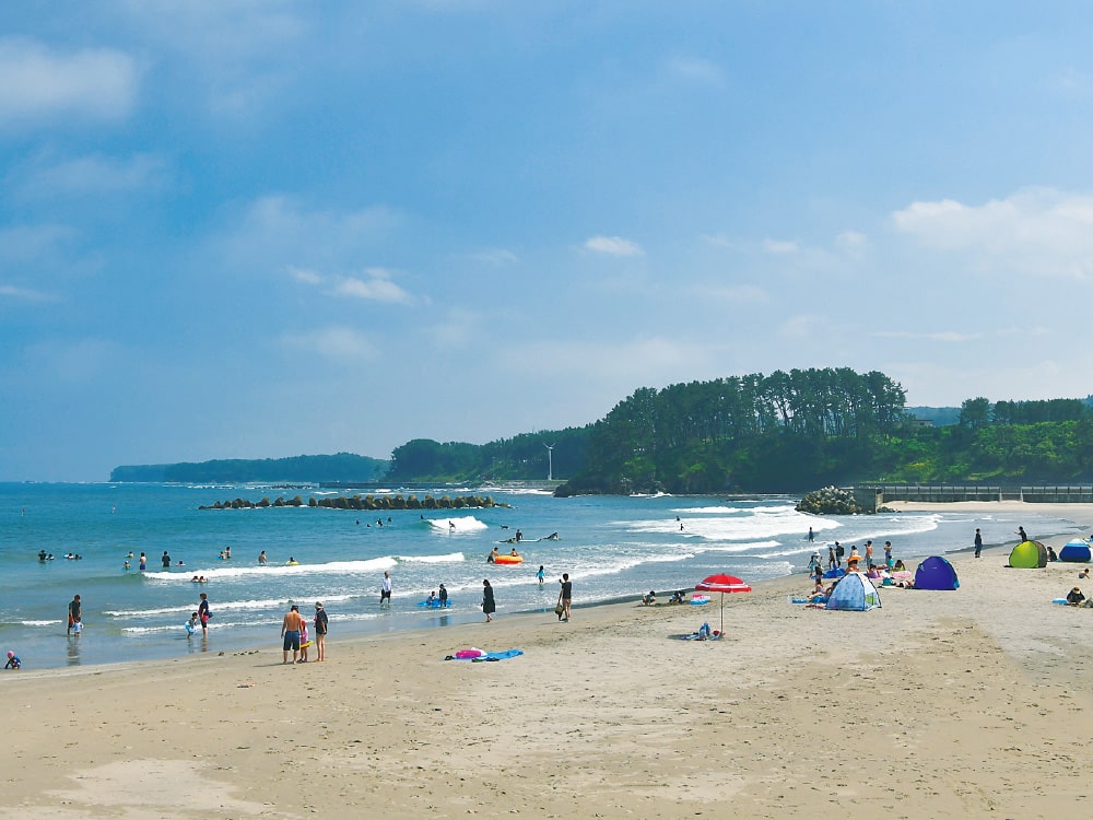
Tofugaura Coast
A rare, gently curving 3.5 km long sandy beach found along the Sanriku Coast. In early summer, Hamanasu roses adorn this azuki suna (bean-shaped sand) beach.
Access: Approx. 3 min walk from Tofugaura-kaigan Station
Tel: 0194-78-2012 (Noda Village Tourism Association)
Fudai, the Earth Village at the eastern edge of the 40th parallel north. The Pacific Ocean seen from Kurosaki stretches endlessly, vast and blue.
Tourist accommodation information & inquiries:
Tourism Promotion Office, Fudai Village/Tel: 0194-35-2115/9-13-2 Doya, Fudai, Iwate/https://www.vill.fudai.iwate.jp
Roadside Station Aonokuni Fudai/Tel: 0194-35-2411/Sanriku Railway Fudai Sta. Bldg., 9-5-3 Doya, Fudai, Iwate/http://aonokuni.jp
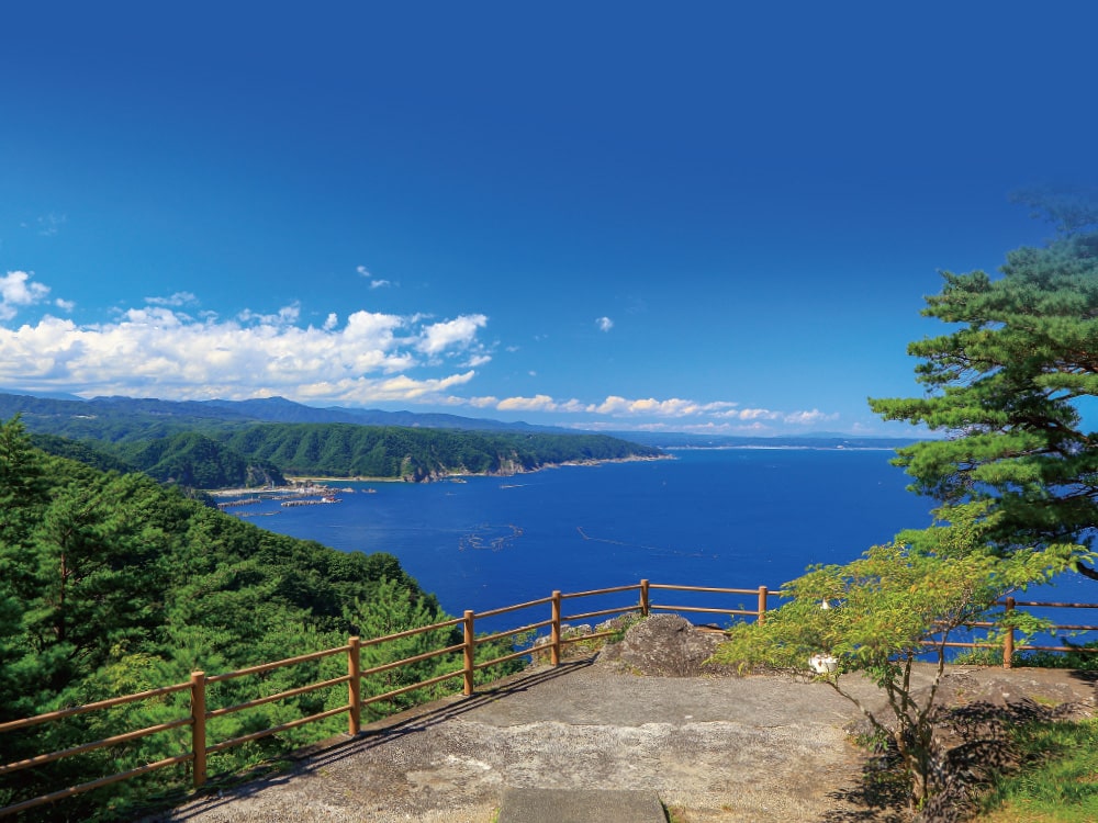
Kurosaki
Observatory
An observatory offering panoramic views of the Pacific Ocean's horizon and the northern Sanriku Geopark, stretching from Kurosaki to Kuji City.
Access: Get off at Kurosaki-tenbodai on the Fudai Village bus
Tel: 0194-35-2115 (Fudai Village Tourism Association)
MiddleArea
Kitayamazaki and Unosu Cliffs are some of the most beautiful coastal cliffs in Japan. The stunning coastline is breathtaking.
Tourist accommodation information & inquiries:
Tanohata Village Tourist Information Center/Tel: 0194-33-3248/129-10 Kitayama, Tanohata, Iwate/http://www.vill.tanohata.iwate.jp
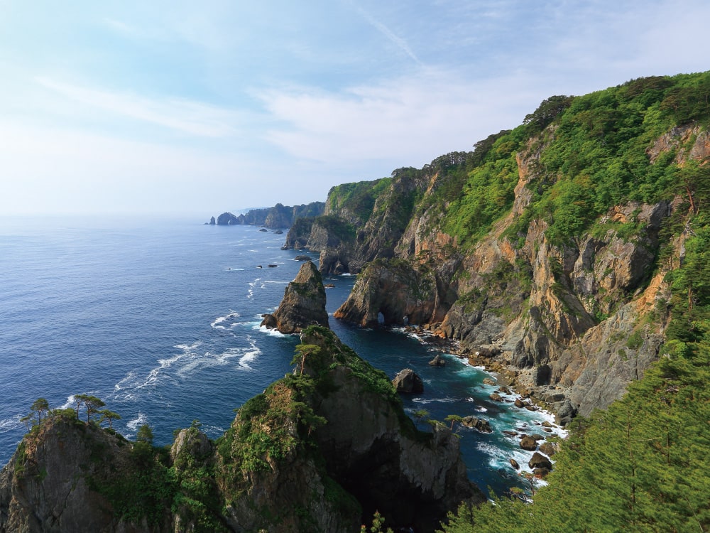
Kitayamazaki
Cliffs
A nationally renowned scenic spot with approximately 8 km of 200-meter-high cliffs. The awe-inspiring scale is breathtaking.
Access: Approx. 20 min by car from Tanohata Station
Tel: 0194-33-3248 (Tanohata Village Tourist Information Center)
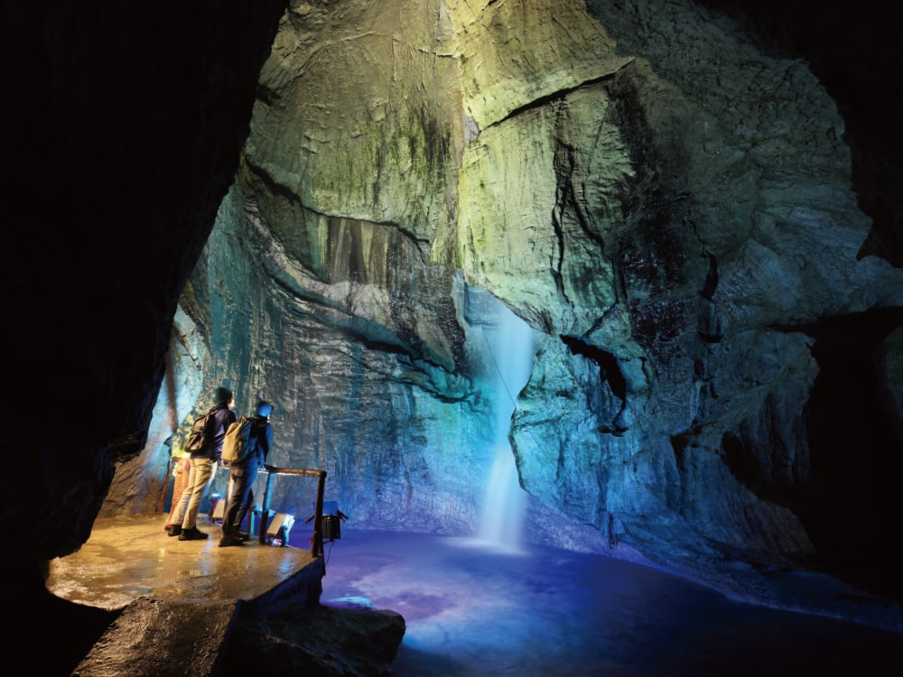
The town known as a "Symphony of Forest and Water." Discover the mystery and adventure of the underground at Ryusendo and Akkado Caves.
Tourist accommodation information & inquiries:
Iwaizumi Town Tourism Association/Tel: 0194-22-4755/1-1 Kannari, Iwaizumi, Iwaizumi, Iwate/https://iwaizumi-kankou.jp
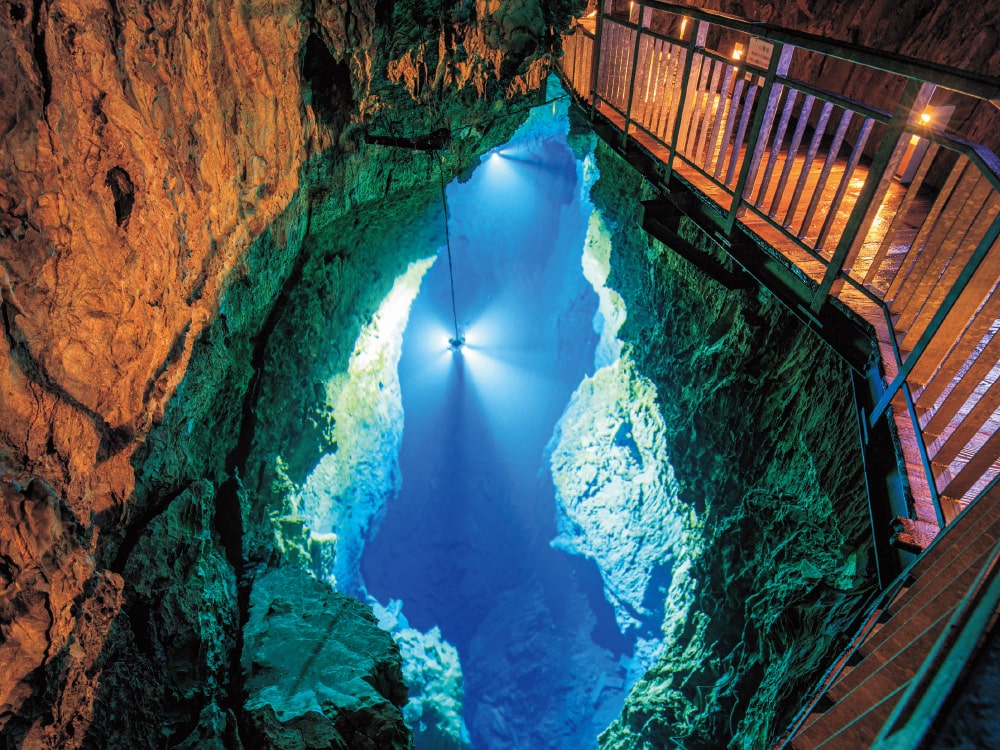
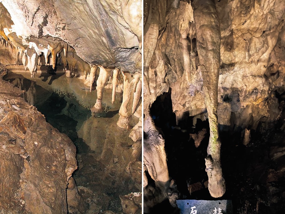
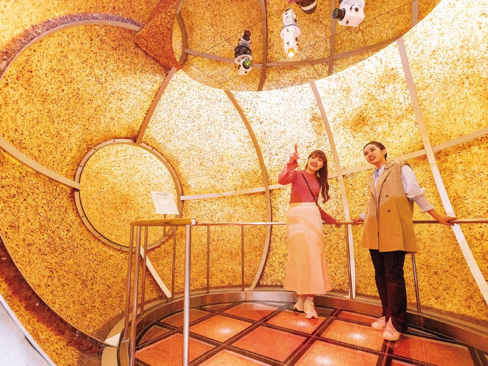
Ryusendo Cave
This giant limestone cave is approximately 200 million years old. It is home to an underground lake known as "Dragon Blue," which boasts world-class transparency.
Access: Approx. 120 min by bus from Morioka Station
Tel: 0194-22-2566
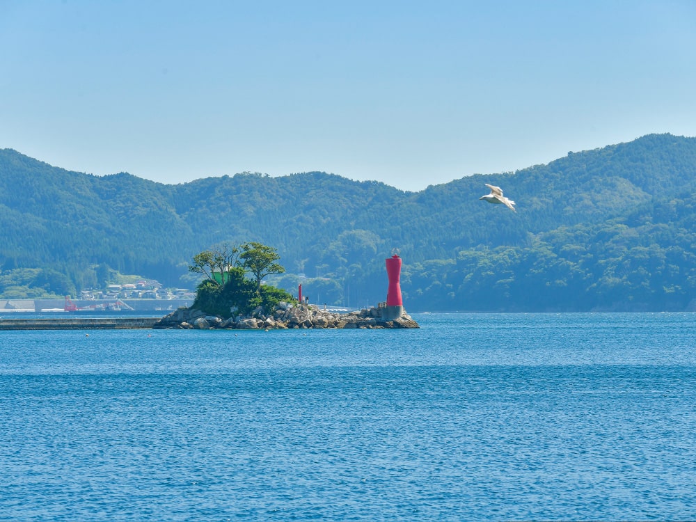
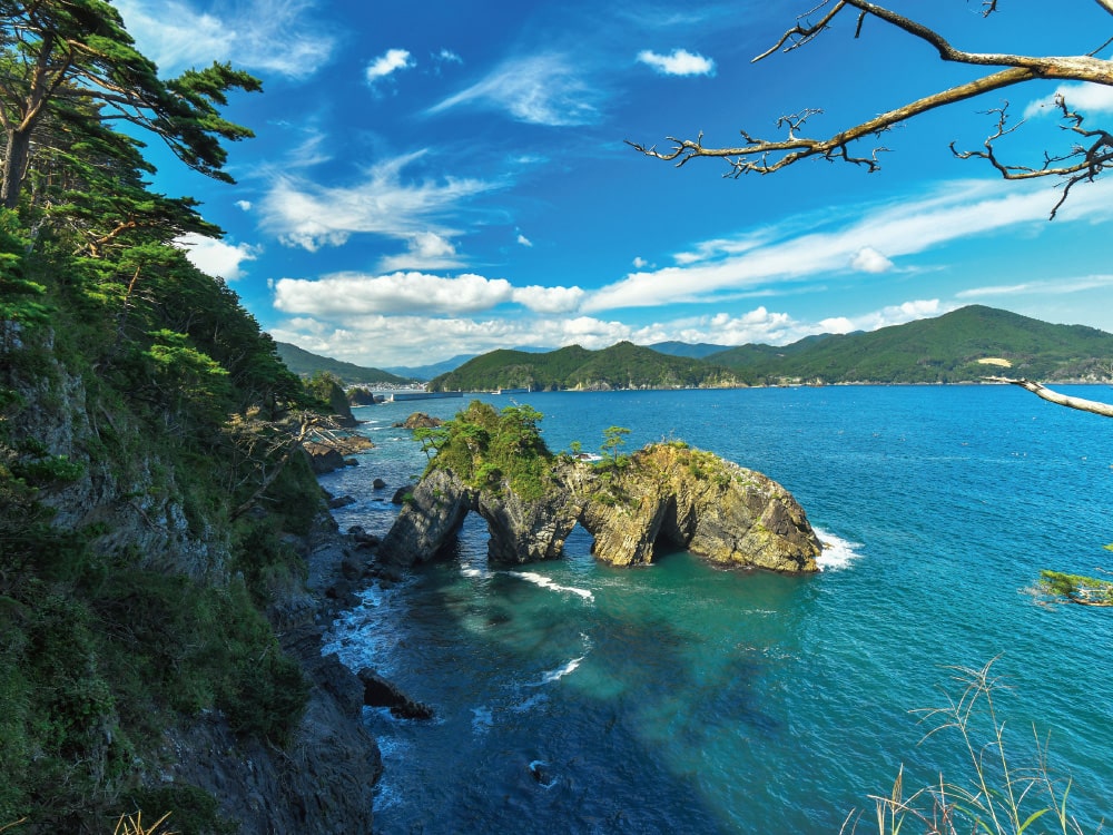
Located almost in the center of the Sanriku Coast, it serves as the base for exploring Sanriku. Enjoy the magnificent views, history, culture, and gourmet cuisine.
Tourist accommodation information & inquiries:
Tourism Division, Miyako City/Tel: 0193-62-2111/1-1-30 Miyamachi, Miyako, Iwate/https://www.city.miyako.iwate.jp
Miyako Tourist Information Center/Tel: 0193-62-3574/1-1-80 Miyamachi, Miyako, Iwate (next to Miyako Sta.)
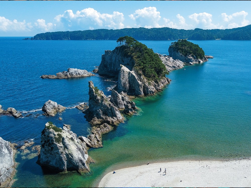
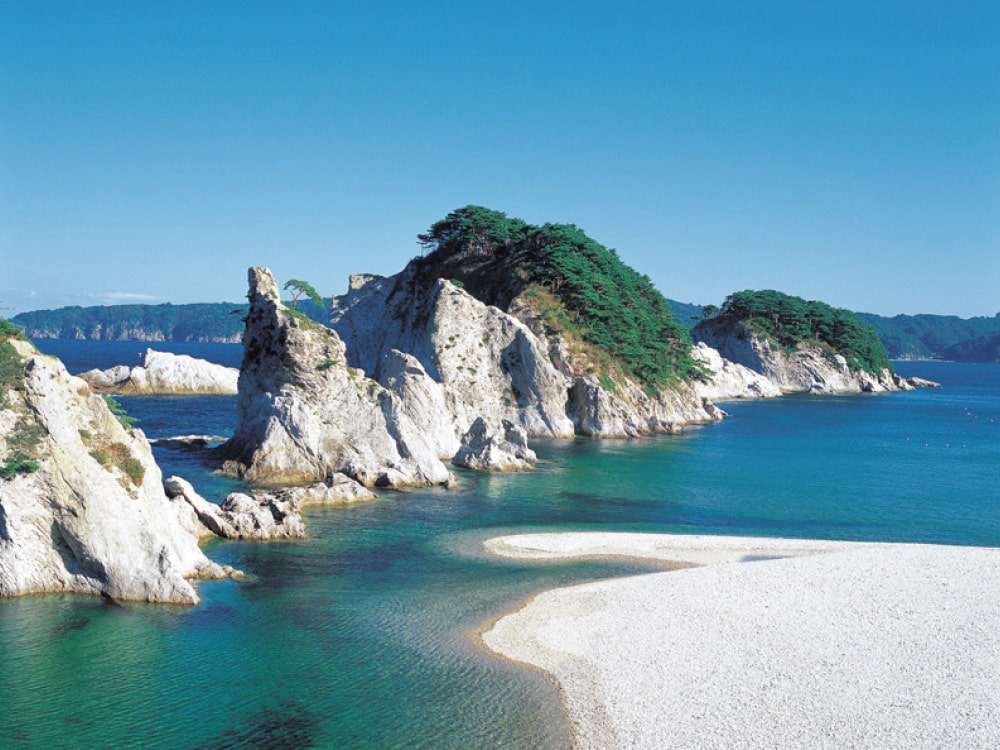
Jodogahama
Beach
Located near the center of Sanriku Fukko National Park, this is one of the representative scenic spots of Sanriku. The contrast of the white rock surface, the blue sea, and the green pine trees is captivating. Enjoy the breathtaking views of the Jodogahama area aboard the sightseeing boat "Miyako Umineko Maru."
Access: Approx. 10 min by car from Miyako Station
Tel: 0193-62-3534 (Miyako Tourism and Culture Exchange Association)
https://www.jodo-yuransen.jp/en/
Aquaculture rafts line the calm waters of Yamada Bay.
You can quietly feel the abundance of the sea and mountains in this town.
Tourist accommodation information & inquiries:
Fisheries Commerce and Industry Division, Yamada Town/Tel: 0193-82-3111/3-20 Hachiman-cho, Yamada, Iwate/https://www.town.yamada.iwate.jp
Yamada Town Tourism Association/Tel: 0193-65-7901/2-1-6 Osawa, Yamada, Iwate/https://www.yamada-kankou.jp
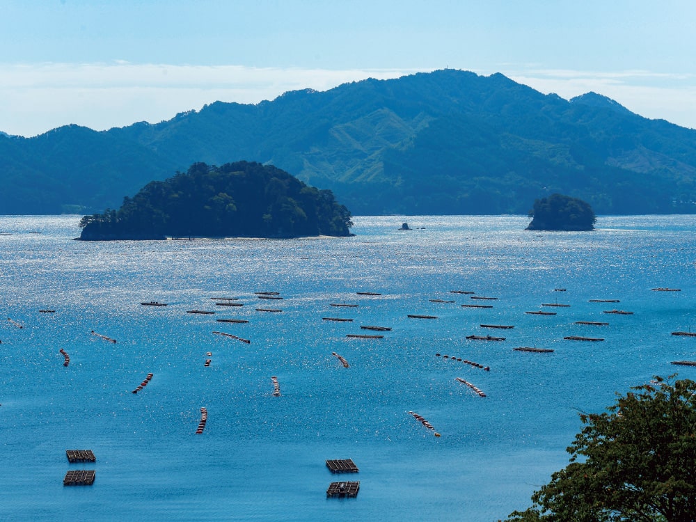
Yamada Bay and
Orandajima Island
Named Orandajima Island (Dutch Island) after a Dutch ship anchored here during the Edo period, this uninhabited island has become a popular spot for hands-on sightseeing.
Tel: 0193-65-7901 (Yamada Town Tourism Association)
The beloved symbol of the town, Horaijima Island, floats peacefully in the sea. This is a town of nature, with the sea and mountains that offers warm hospitality.
Tourist accommodation information & inquiries:
Otsuchi Town Tourism Exchange Association/Tel: 0193-42-5121/34-4 Shincho, Otsuchi, Iwate/https://otsuchi-ta.com
Horaijima Island
Horaijima Island in Otsuchi Bay is affectionately known as "Hyotanjima Island" (Gourd Island). The island's shrine enshrines Benzaiten (goddess of eloquence).
Tel: 0193-42-5121(Otsuchi Town Tourism Exchange Association)
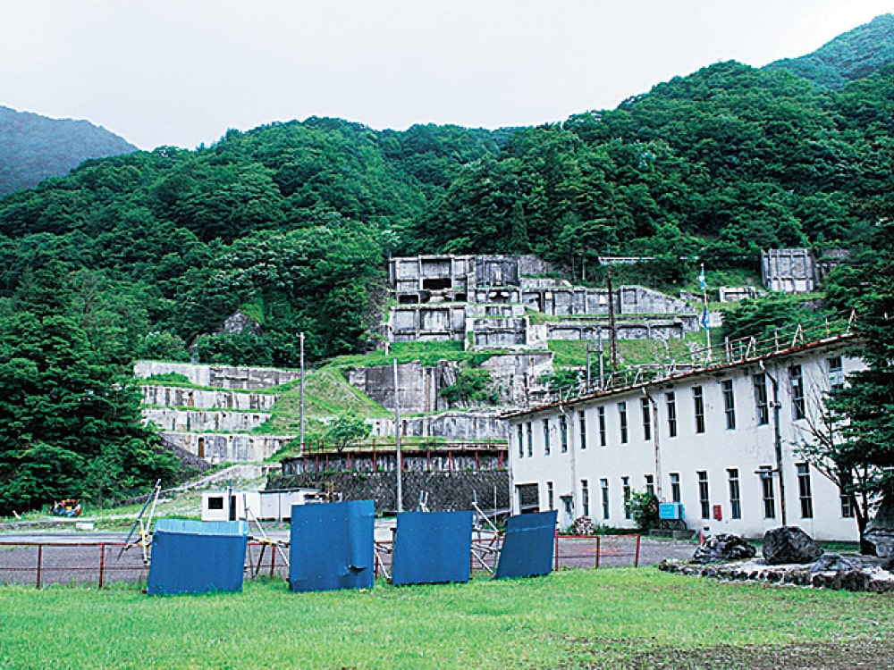
Visit Hashino Iron Mine, a World Heritage Site, and explore the beautiful ria coastline to enjoy this town known for its iron, fish, and rugby.
Tourist accommodation information & inquiries:
Kamaishi Tourist Information Center/Tel: 0193-27-8172/1F, Sea Plaza Kamaishi 22-1 Suzukocho, Kamaishi, Iwate/https://kamaishi-kankou.jp
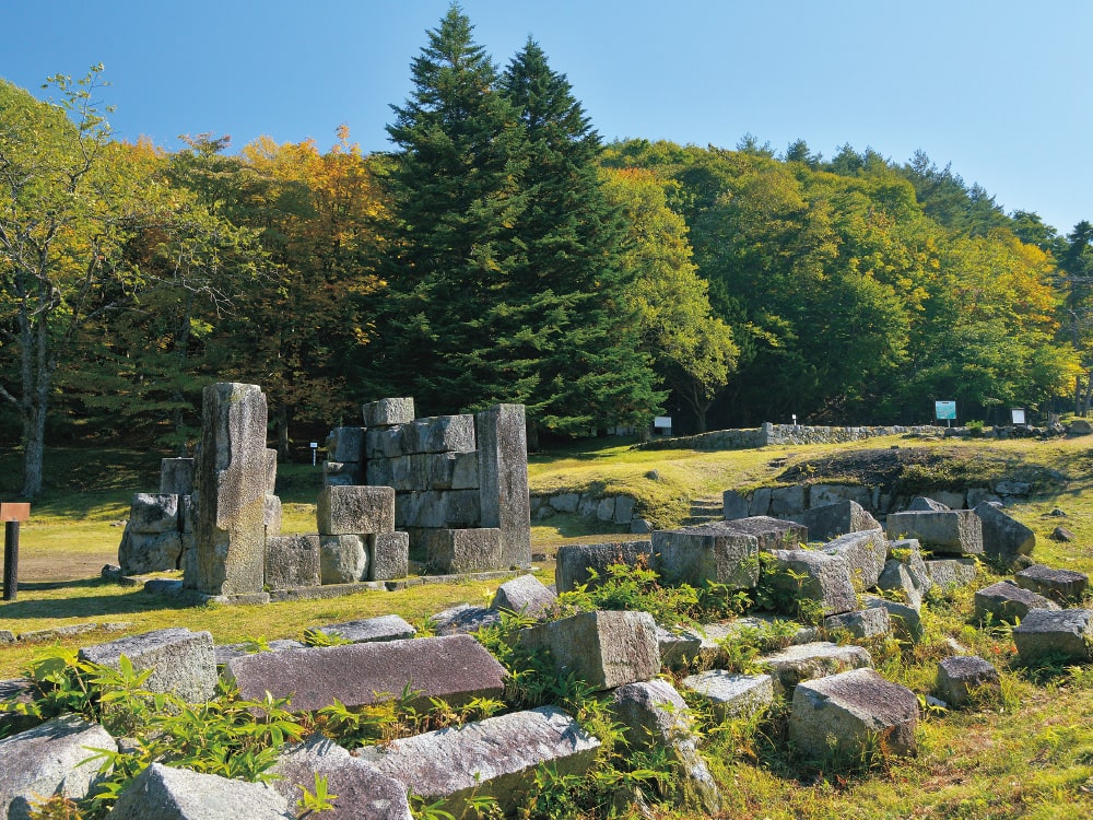
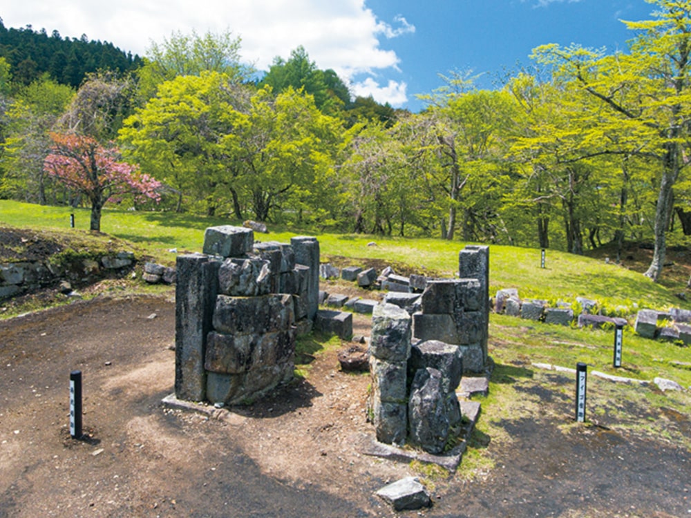
Hashino Iron Mine
You can see the remains of Japan's oldest surviving Western-style blast furnace, built under the guidance of Takato Oshima, the father of modern steelmaking.
Access: Approx. 30 min by car from Unosumai Station
Approx. 30 min by car from Kamaishi-kita IC
Tel: 0193-54-5250(Hashino Iron Mine Information Center) *Closed 12/9-3/31
SouthernArea
A town where you can encounter the dynamic beauty of the ria coastline's natural formations and get enveloped by the power of the eternal earth.
Tourist accommodation information & inquiries:
Tourism Exchange Promotion Office, Ofunato City/Tel: 0192-27-3111/15 Utsunosawa, Sakari-cho, Ofunato, Iwate/https://www.city.ofunato.iwate.jp/site/ofunatrip/
Ofunato City Tourism and Products Association/Tel: 0192-21-1922/1F, Ofunato City Disaster Prevention and Tourism Exchange Center, 7-6 Chaya-mae, Ofunato, Ofunato, Iwate/https://sanriku-ofunato.or.jp
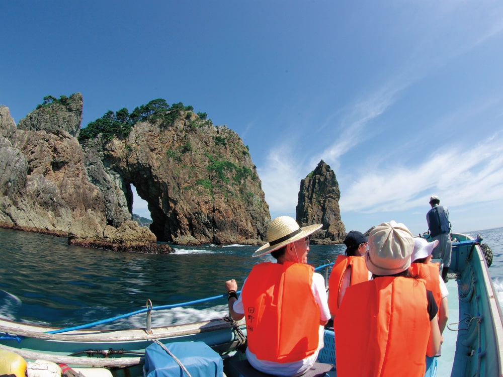
Anatoshiiso Rock
A representative view of the Goishi Coast. This unique rock formation has large holes formed by the erosion of seawater, and sightseeing boats that pass through these holes are also popular.
Approx. 12 min by car from Ofunato-Goishikaigan IC
Tel: 0192-29-2359 (Goishi Coast Information Center)
A town with traditional storehouses that retains the atmosphere of a post town connecting the sea and inland of Sanriku. The tranquil Kesen River flows quietly through the town.
Tourist accommodation information & inquiries:
Sumita Town Tourism Association/Tel: 0192-46-3861/88-1 Kawamukai, Setamai, Sumita, Iwate/https://sumita-kankou.wixsite.com/sumita-kankou
Rokando Cave
The Amanoiwato-no-Taki waterfall in Rokando Cave has a height of 29 meters and boasts one of the largest scales among cave waterfalls in Japan.
Access: Approx. 5 min by car from Rokando IC
Tel: 0192-48-2756 (Rokando Cave Tourist Center)
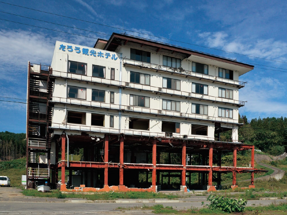
Steadily heading towards reconstruction for the future. The remaining symbols of reconstruction pledge to pass down the lessons of the earthquake to future generations.
Tourist accommodation information & inquiries:
Rikuzentakata City Tourism and Products Association/Tel: 0192-54-5011/300-2 Namisugi, Takata-cho, Rikuzentakata, Iwate/https://takanavi.org
Takatamatsubara
Memorial Park
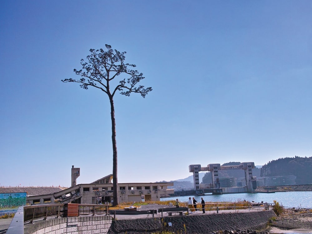
Established to commemorate and console the victims of the Great East Japan Earthquake, and to pass down the memories and lessons of the disaster, while also serving as a symbol of the strong determination towards reconstruction.
Access: Approx. 7 min by car from Rikuzentakata IC
Tel: 0192-22-8560
Kesennuma is one of Japan's leading port towns. Its diverse scenery along the ria coastline and fresh seafood are captivating.
Tourist accommodation information & inquiries:
Kesennuma City Tourism Association/Tel: 0226-22-4560/7-13 Uoichiba-mae, Kesennuma, Miyagi/https://kesennuma-kanko.jp (Kesennuma official tourist site “Kesennumasa kite kerain”)
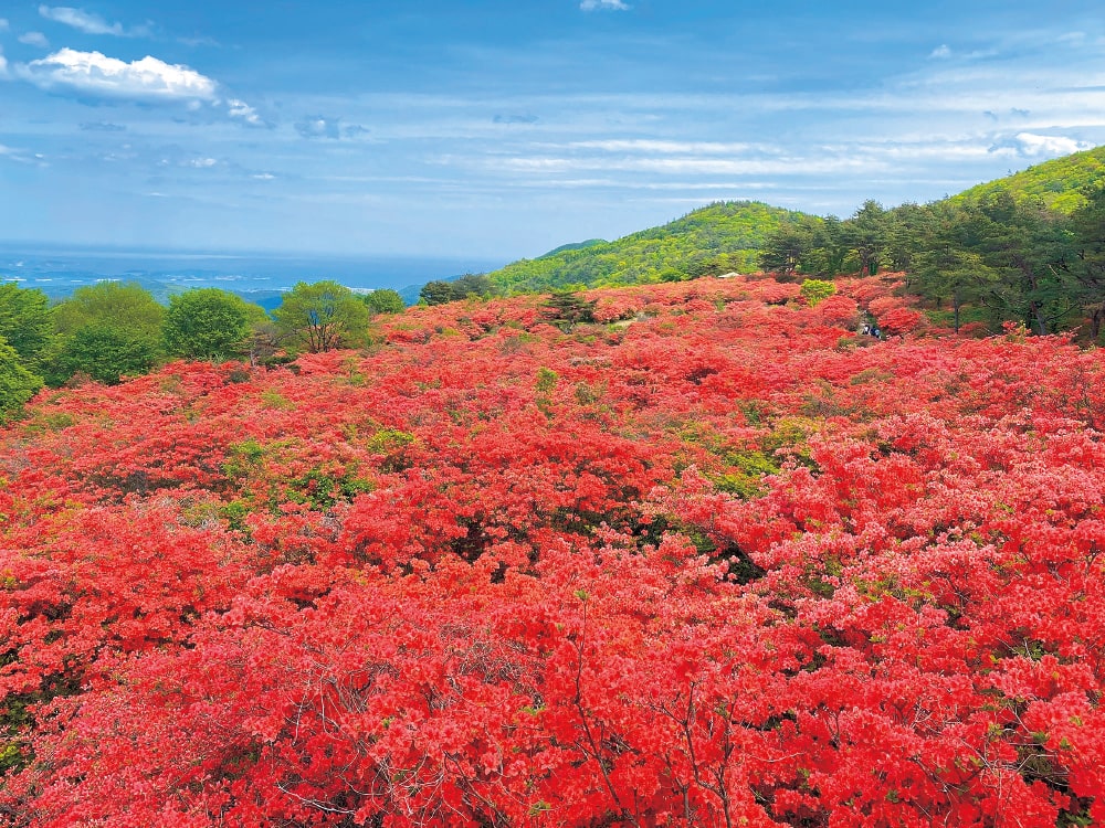
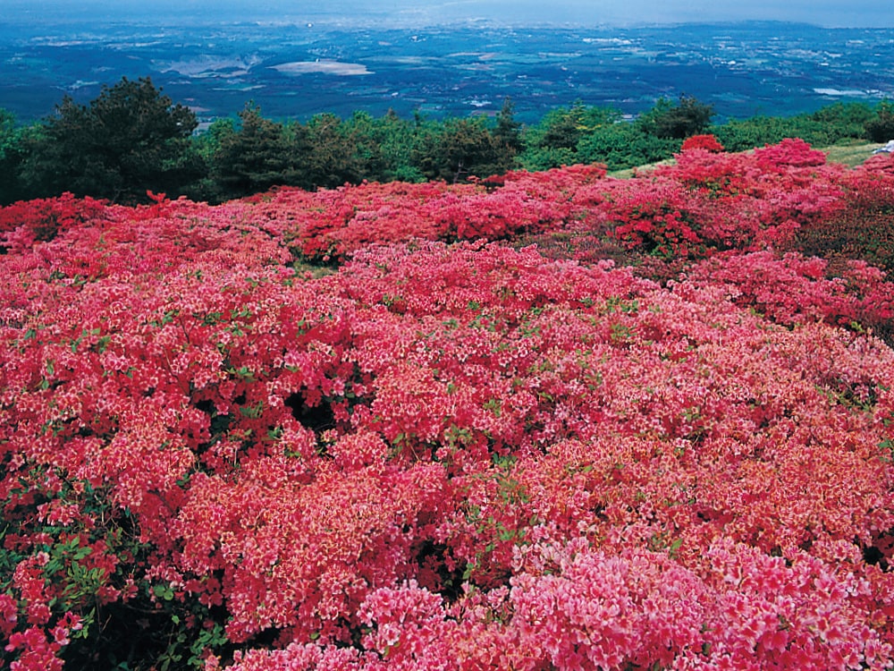
Mt. Tokusenjo
One of Japan's largest azalea viewing spots. From mid to late May, approximately 500,000 Yama-tsutsuji azaleas and Japanese azaleas come into full bloom, painting the entire mountain in shades of red and orange.
Access: Approx. 30 min by car from Kesennuma Chuo IC
Tel: 0226-22-4560 (Kesennuma City Tourism Association)
A coastal town with a beautiful contrast of sea and mountains
Shizugawa Bay, designated as a Ramsar Convention wetland, is a bountiful sea that nurtures the treasures of Sanriku.
Tourist accommodation information & inquiries:
Commerce, Industry and Tourism Division, Minamisanriku Town/Tel: 0226-46-1385/101 Numada, Shizugawa, Minamisanriku, Miyagi/http://www.town.minamisanriku.miyagi.jp
Minamisanriku Town Tourism Association/Tel: 0226-47-2550/200-1 Itsukamachi, Shizugawa, Minamisanriku, Miyagi/https://www.m-kankou.jp
San Ore Sodehama
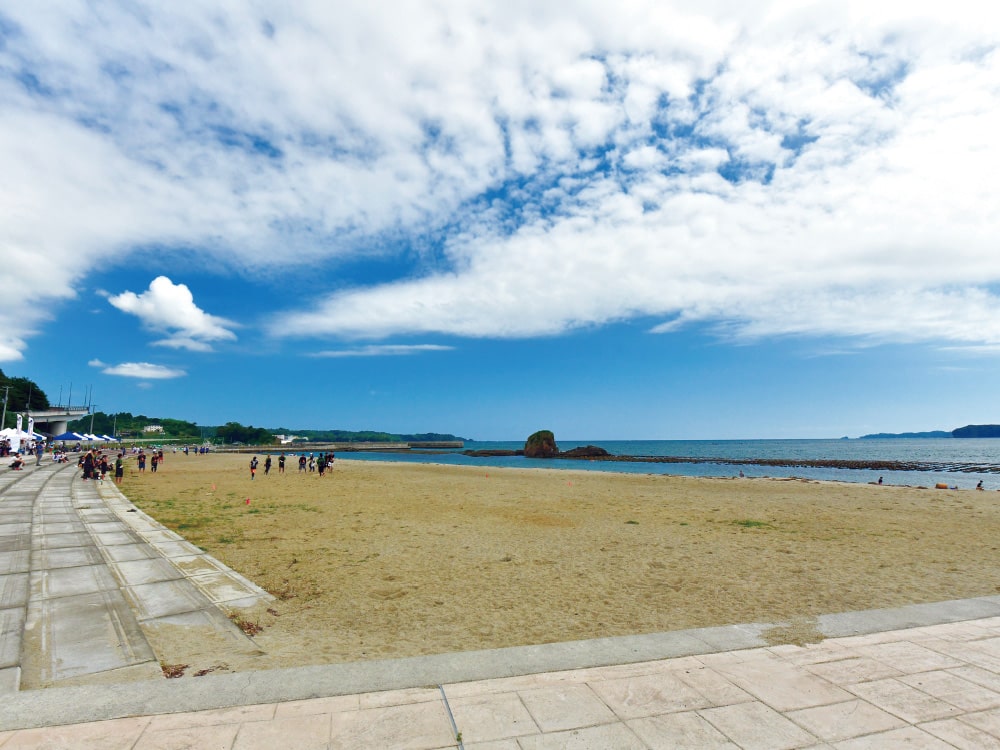
Swimming Beach
A calm artificial seawater beach located in an inland bay, where even young children can safely play. The scenery of the sea and mountains is also beautiful.
Access: Approx. 6 min by car from Minamisanriku Kaigan IC
Tel: 0226-47-2550 (Minamisanriku Town Tourism Association)
A port town surrounded by the cobalt blue sea. On New Year's Day, the first sunrise can be seen in front of the Brick Road.
Tourist accommodation information & inquiries:
Industrial Promotion Division, Onagawa Town/Tel: 0225-54-3131/1-1-1 Onagawa, Onagawa, Miyagi/https://www.town.onagawa.miyagi.jp
Onagawa Town Tourism Association/Tel: 0225-54-4328/2-16-5 Onagawa, Onagawa, Miyagi/https://www.onagawa.org
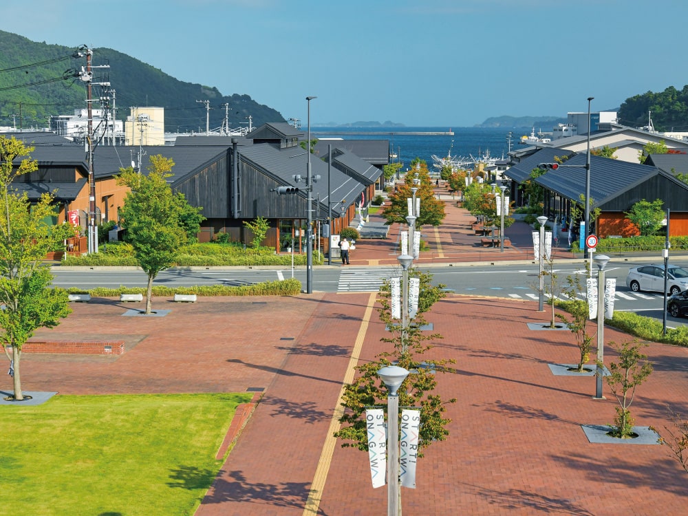
Roadside Station
Onagawa
Around the open-air brick street, you'll find various restaurants where you can enjoy local cuisine from Onagawa, and handcraft workshops, etc.
Access: In front of Onagawa Station
Tel: 0225-24-8118 (Onagawa Mirai Sozo Co., Ltd.)
A town boasting fresh seasonal seafood from off the coast of Sanriku / Kinkasan Island, one of the world's three major fishing grounds. Enjoy the food along with the scenery of the ria coastline.
Tourist accommodation information & inquiries:
Ishinomaki Tourism Association/Tel: 0225-93-6448/2-11-21 Chuo, Ishinomaki, Miyagi/https://i-kanko.com
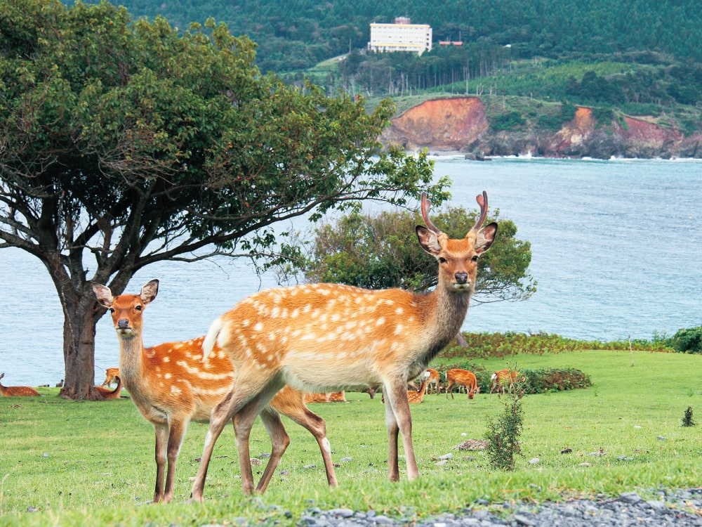
Kinkasan Island
Kinkasan Island, off the Oshika Peninsula, is a sacred place of faith. The island has many places for worship, and the deer are protected as messengers of the gods.
Kinkasan koganeyama shrine has a legend that if you visit there for three consecutive years, you will never have to worry about money for the rest of your life.
Access: Approx. 20 min by boat from Ayukawa Port
Tel: 0225-45-2114
(Oshika General Branch Office, Ishinomaki City)
ACCESS GUIDE
As of Jun. 2024
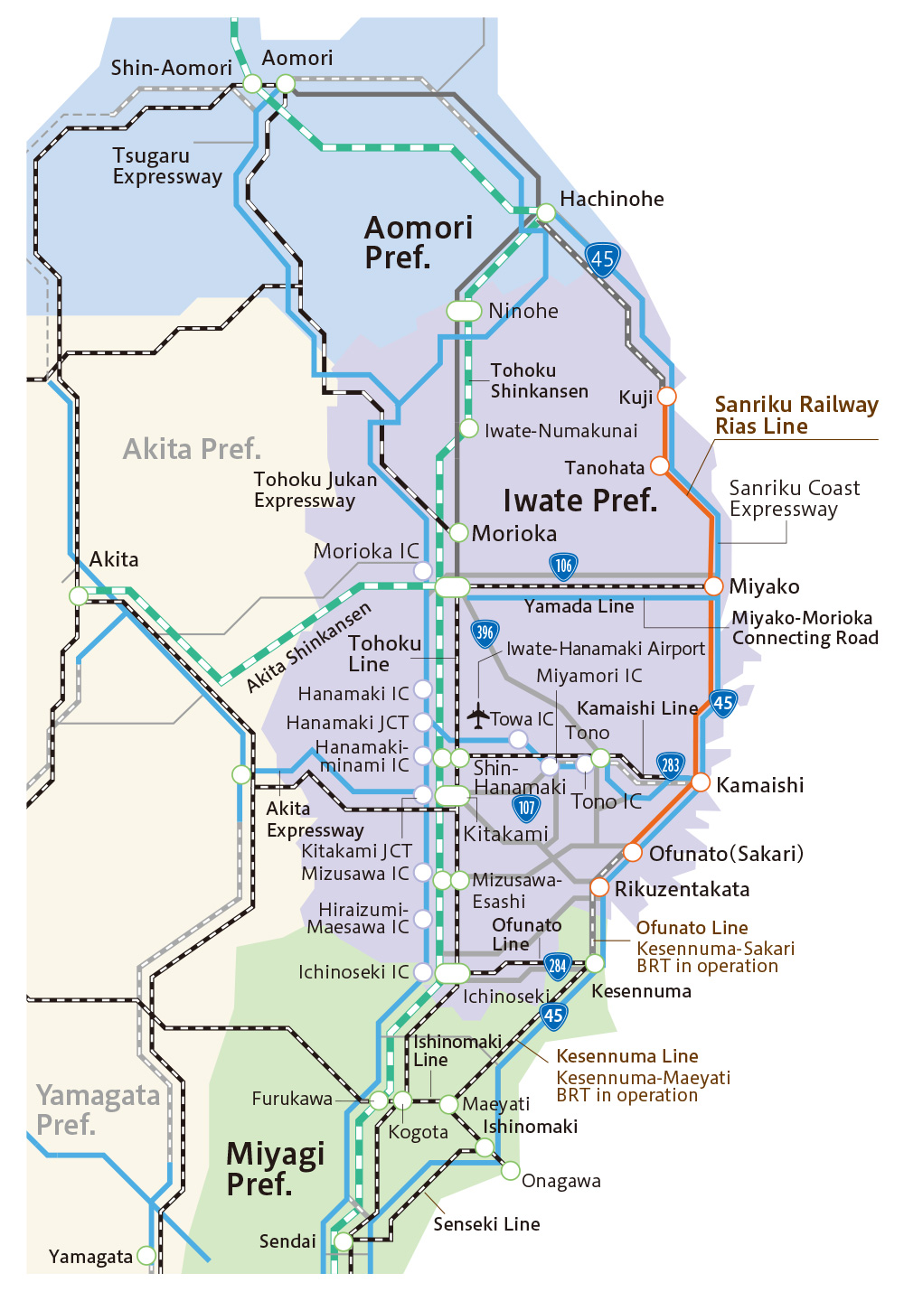
To Sanriku by car
- Aomori–Hacninohe (Prefectural Road No.44, Kamikita Expressway, etc.)
- Approx. 1hr 30min
- Hachinohe–Kuji (Sanriku Coast Expressway)
- Approx. 40min
- Ninohe–Kuji (Prefectural Road No.24, No.42, National Route No.281)
- Approx. 1hr 10min
- Morioka–Miyako (National Route No.106, Miyako-Morioka Connecting Road)
- Approx. 1hr 15min
- Hanamaki–Kamaishi (Kamaishi Expressway)
- Approx. 1hr 5min
- Kitakami–Ofunato (National Route No.107, Kamaishi Expressway)
- Approx. 1hr 20min
- Oshu–Ofunato (National Route No.397, No.107)
- Approx. 1hr 20min
- Ichinoseki–Rikuzentakata (Prefectural Road No.19, National Route No.343)
- Approx. 1hr 20min
- Ichinoseki–Kesennuma (National Route No.284)
- Approx. 1hr 10min
- Sendai–Miyako (Sanriku Coast Expressway)
- Approx. 2hr 45min
To Sanriku by JR
- Shin-Aomori Sta.–Morioka Sta. (JR Tohoku Shinkansen)
- Approx. 55min
- Aomori Sta.–Hachinohe Sta. (Aoimori Railway)
- Approx. 1hr 30min
- Misawa Sta.–Hachinohe Sta. (Aoimori Railway)
- Approx. 20min
- Morioka Sta.–Miyako Sta. (JR Yamada Line)
- Approx. 2hr 10min
- Hanamaki Sta.–Kamaishi Sta. (JR Kamaishi Line)
- Approx. 1hr 50min
- Ichinoseki Sta.–Kesennuma Sta. (JR Ofunato Line)
- Approx. 1hr 20min
- Akita Sta.–Morioka Sta. (JR Akita Shinkansen)
- Approx. 1hr 30min
- Sendai Sta.–Morioka Sta. (JR Tohoku Shinkansen)
- Approx. 40min
- Tokyo Sta.–Morioka Sta. (JR Tohoku Shinkansen)
- Approx. 2hr 20min
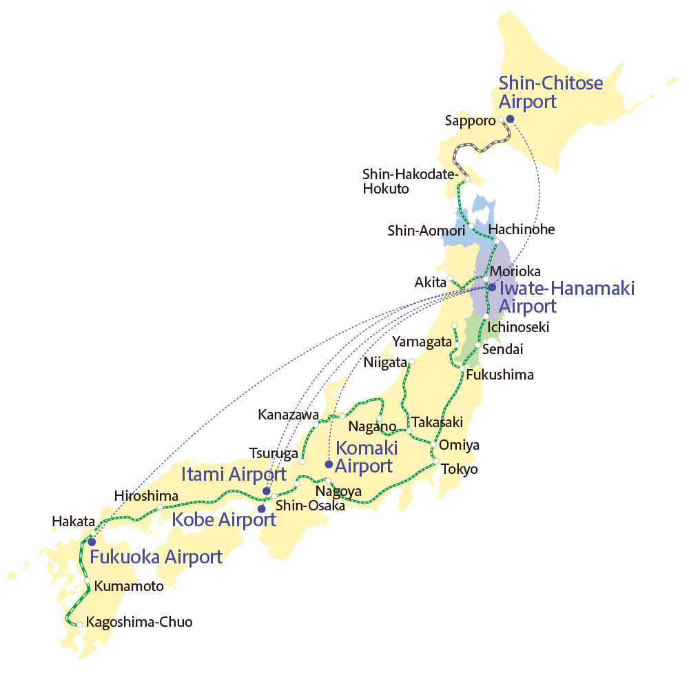
To Sanriku by airplane
- Sapporo (Shin-Chitose)–Iwate-Hanamaki
- Approx. 55min
- Tokyo (Haneda)–Aomori
- Approx. 1hr 15min
- Tokyo (Haneda)–Misawa
- Approx. 1hr 15min
- Tokyo (Haneda)–Akita
- Approx. 1hr 5min
- Nagoya (Komaki)–Iwate-Hanamaki
- Approx. 1hr 10min
- Kobe–Iwate-Hanamaki
- Approx. 1hr 30min
- Osaka (Itami)–Iwate-Hanamaki
- Approx. 1hr 20min
- Fukuoka–Iwate-Hanamaki
- Approx. 2hr
このサイトは令和5年度国立公園等資源整備事業費補助金(国立公園等多言語解説等整備事業)を活用し、制作いたしました。
This website was created using the FY2023 subsidy for the National Parks Resource Development Project (National Parks Multilingual Explanation Improvement Project).
Sanriku Geopark Promotion Council

Tel: 0193-64-1230
2F Miyako District Godochosha Bldg., 1-20 Satsuki-cho, Miyako, Iwate 027-0072
https://sanriku-geo.com
Northern Iwate Transportation Inc.

Tel: 019-641-7711
1-17-18 Kuriyagawa, Morioka, Iwate 020-0124
http://www.iwate-kenpokubus.co.jp
Passenger Sales Dept.,
Sanriku Railway Co., Ltd.

Tel : 0193-62-7000
Miyako Sta. Bldg., 1-1-80 Miyamachi, Miyako,
Iwate 027-0052
http://www.sanrikutetsudou.com